Get trending papers in your email inbox once a day!
Get trending papers in your email inbox!
Subscribe
ROVER: A Multi-Season Dataset for Visual SLAM
Robust SLAM is a crucial enabler for autonomous navigation in natural, semi-structured environments such as parks and gardens. However, these environments present unique challenges for SLAM due to frequent seasonal changes, varying light conditions, and dense vegetation. These factors often degrade the performance of visual SLAM algorithms originally developed for structured urban environments. To address this gap, we present ROVER, a comprehensive benchmark dataset tailored for evaluating visual SLAM algorithms under diverse environmental conditions and spatial configurations. We captured the dataset with a robotic platform equipped with monocular, stereo, and RGBD cameras, as well as inertial sensors. It covers 39 recordings across five outdoor locations, collected through all seasons and various lighting scenarios, i.e., day, dusk, and night with and without external lighting. With this novel dataset, we evaluate several traditional and deep learning-based SLAM methods and study their performance in diverse challenging conditions. The results demonstrate that while stereo-inertial and RGBD configurations generally perform better under favorable lighting and moderate vegetation, most SLAM systems perform poorly in low-light and high-vegetation scenarios, particularly during summer and autumn. Our analysis highlights the need for improved adaptability in visual SLAM algorithms for outdoor applications, as current systems struggle with dynamic environmental factors affecting scale, feature extraction, and trajectory consistency. This dataset provides a solid foundation for advancing visual SLAM research in real-world, semi-structured environments, fostering the development of more resilient SLAM systems for long-term outdoor localization and mapping. The dataset and the code of the benchmark are available under https://iis-esslingen.github.io/rover.

Towards Robust Sensor-Fusion Ground SLAM: A Comprehensive Benchmark and A Resilient Framework
Considerable advancements have been achieved in SLAM methods tailored for structured environments, yet their robustness under challenging corner cases remains a critical limitation. Although multi-sensor fusion approaches integrating diverse sensors have shown promising performance improvements, the research community faces two key barriers: On one hand, the lack of standardized and configurable benchmarks that systematically evaluate SLAM algorithms under diverse degradation scenarios hinders comprehensive performance assessment. While on the other hand, existing SLAM frameworks primarily focus on fusing a limited set of sensor types, without effectively addressing adaptive sensor selection strategies for varying environmental conditions. To bridge these gaps, we make three key contributions: First, we introduce M3DGR dataset: a sensor-rich benchmark with systematically induced degradation patterns including visual challenge, LiDAR degeneracy, wheel slippage and GNSS denial. Second, we conduct a comprehensive evaluation of forty SLAM systems on M3DGR, providing critical insights into their robustness and limitations under challenging real-world conditions. Third, we develop a resilient modular multi-sensor fusion framework named Ground-Fusion++, which demonstrates robust performance by coupling GNSS, RGB-D, LiDAR, IMU (Inertial Measurement Unit) and wheel odometry. Codes and datasets are publicly available.
MAC-VO: Metrics-aware Covariance for Learning-based Stereo Visual Odometry
We propose the MAC-VO, a novel learning-based stereo VO that leverages the learned metrics-aware matching uncertainty for dual purposes: selecting keypoint and weighing the residual in pose graph optimization. Compared to traditional geometric methods prioritizing texture-affluent features like edges, our keypoint selector employs the learned uncertainty to filter out the low-quality features based on global inconsistency. In contrast to the learning-based algorithms that model the scale-agnostic diagonal weight matrix for covariance, we design a metrics-aware covariance model to capture the spatial error during keypoint registration and the correlations between different axes. Integrating this covariance model into pose graph optimization enhances the robustness and reliability of pose estimation, particularly in challenging environments with varying illumination, feature density, and motion patterns. On public benchmark datasets, MAC-VO outperforms existing VO algorithms and even some SLAM algorithms in challenging environments. The covariance map also provides valuable information about the reliability of the estimated poses, which can benefit decision-making for autonomous systems.
Fast-UMI: A Scalable and Hardware-Independent Universal Manipulation Interface
Collecting real-world manipulation trajectory data involving robotic arms is essential for developing general-purpose action policies in robotic manipulation, yet such data remains scarce. Existing methods face limitations such as high costs, labor intensity, hardware dependencies, and complex setup requirements involving SLAM algorithms. In this work, we introduce Fast-UMI, an interface-mediated manipulation system comprising two key components: a handheld device operated by humans for data collection and a robot-mounted device used during policy inference. Our approach employs a decoupled design compatible with a wide range of grippers while maintaining consistent observation perspectives, allowing models trained on handheld-collected data to be directly applied to real robots. By directly obtaining the end-effector pose using existing commercial hardware products, we eliminate the need for complex SLAM deployment and calibration, streamlining data processing. Fast-UMI provides supporting software tools for efficient robot learning data collection and conversion, facilitating rapid, plug-and-play functionality. This system offers an efficient and user-friendly tool for robotic learning data acquisition.


Heterogeneous LiDAR Dataset for Benchmarking Robust Localization in Diverse Degenerate Scenarios
The ability to estimate pose and generate maps using 3D LiDAR significantly enhances robotic system autonomy. However, existing open-source datasets lack representation of geometrically degenerate environments, limiting the development and benchmarking of robust LiDAR SLAM algorithms. To address this gap, we introduce GEODE, a comprehensive multi-LiDAR, multi-scenario dataset specifically designed to include real-world geometrically degenerate environments. GEODE comprises 64 trajectories spanning over 64 kilometers across seven diverse settings with varying degrees of degeneracy. The data was meticulously collected to promote the development of versatile algorithms by incorporating various LiDAR sensors, stereo cameras, IMUs, and diverse motion conditions. We evaluate state-of-the-art SLAM approaches using the GEODE dataset to highlight current limitations in LiDAR SLAM techniques. This extensive dataset will be publicly available at https://geode.github.io, supporting further advancements in LiDAR-based SLAM.

InteriorNet: Mega-scale Multi-sensor Photo-realistic Indoor Scenes Dataset
Datasets have gained an enormous amount of popularity in the computer vision community, from training and evaluation of Deep Learning-based methods to benchmarking Simultaneous Localization and Mapping (SLAM). Without a doubt, synthetic imagery bears a vast potential due to scalability in terms of amounts of data obtainable without tedious manual ground truth annotations or measurements. Here, we present a dataset with the aim of providing a higher degree of photo-realism, larger scale, more variability as well as serving a wider range of purposes compared to existing datasets. Our dataset leverages the availability of millions of professional interior designs and millions of production-level furniture and object assets -- all coming with fine geometric details and high-resolution texture. We render high-resolution and high frame-rate video sequences following realistic trajectories while supporting various camera types as well as providing inertial measurements. Together with the release of the dataset, we will make executable program of our interactive simulator software as well as our renderer available at https://interiornetdataset.github.io. To showcase the usability and uniqueness of our dataset, we show benchmarking results of both sparse and dense SLAM algorithms.
Past, Present, and Future of Simultaneous Localization And Mapping: Towards the Robust-Perception Age
Simultaneous Localization and Mapping (SLAM)consists in the concurrent construction of a model of the environment (the map), and the estimation of the state of the robot moving within it. The SLAM community has made astonishing progress over the last 30 years, enabling large-scale real-world applications, and witnessing a steady transition of this technology to industry. We survey the current state of SLAM. We start by presenting what is now the de-facto standard formulation for SLAM. We then review related work, covering a broad set of topics including robustness and scalability in long-term mapping, metric and semantic representations for mapping, theoretical performance guarantees, active SLAM and exploration, and other new frontiers. This paper simultaneously serves as a position paper and tutorial to those who are users of SLAM. By looking at the published research with a critical eye, we delineate open challenges and new research issues, that still deserve careful scientific investigation. The paper also contains the authors' take on two questions that often animate discussions during robotics conferences: Do robots need SLAM? and Is SLAM solved?

How NeRFs and 3D Gaussian Splatting are Reshaping SLAM: a Survey
Over the past two decades, research in the field of Simultaneous Localization and Mapping (SLAM) has undergone a significant evolution, highlighting its critical role in enabling autonomous exploration of unknown environments. This evolution ranges from hand-crafted methods, through the era of deep learning, to more recent developments focused on Neural Radiance Fields (NeRFs) and 3D Gaussian Splatting (3DGS) representations. Recognizing the growing body of research and the absence of a comprehensive survey on the topic, this paper aims to provide the first comprehensive overview of SLAM progress through the lens of the latest advancements in radiance fields. It sheds light on the background, evolutionary path, inherent strengths and limitations, and serves as a fundamental reference to highlight the dynamic progress and specific challenges.
GigaSLAM: Large-Scale Monocular SLAM with Hierarchical Gaussian Splats
Tracking and mapping in large-scale, unbounded outdoor environments using only monocular RGB input presents substantial challenges for existing SLAM systems. Traditional Neural Radiance Fields (NeRF) and 3D Gaussian Splatting (3DGS) SLAM methods are typically limited to small, bounded indoor settings. To overcome these challenges, we introduce GigaSLAM, the first RGB NeRF / 3DGS-based SLAM framework for kilometer-scale outdoor environments, as demonstrated on the KITTI, KITTI 360, 4 Seasons and A2D2 datasets. Our approach employs a hierarchical sparse voxel map representation, where Gaussians are decoded by neural networks at multiple levels of detail. This design enables efficient, scalable mapping and high-fidelity viewpoint rendering across expansive, unbounded scenes. For front-end tracking, GigaSLAM utilizes a metric depth model combined with epipolar geometry and PnP algorithms to accurately estimate poses, while incorporating a Bag-of-Words-based loop closure mechanism to maintain robust alignment over long trajectories. Consequently, GigaSLAM delivers high-precision tracking and visually faithful rendering on urban outdoor benchmarks, establishing a robust SLAM solution for large-scale, long-term scenarios, and significantly extending the applicability of Gaussian Splatting SLAM systems to unbounded outdoor environments. GitHub: https://github.com/DengKaiCQ/GigaSLAM.
BodySLAM: A Generalized Monocular Visual SLAM Framework for Surgical Applications
Endoscopic surgery relies on two-dimensional views, posing challenges for surgeons in depth perception and instrument manipulation. While Monocular Visual Simultaneous Localization and Mapping (MVSLAM) has emerged as a promising solution, its implementation in endoscopic procedures faces significant challenges due to hardware limitations, such as the use of a monocular camera and the absence of odometry sensors. This study presents BodySLAM, a robust deep learning-based MVSLAM approach that addresses these challenges through three key components: CycleVO, a novel unsupervised monocular pose estimation module; the integration of the state-of-the-art Zoe architecture for monocular depth estimation; and a 3D reconstruction module creating a coherent surgical map. The approach is rigorously evaluated using three publicly available datasets (Hamlyn, EndoSLAM, and SCARED) spanning laparoscopy, gastroscopy, and colonoscopy scenarios, and benchmarked against four state-of-the-art methods. Results demonstrate that CycleVO exhibited competitive performance with the lowest inference time among pose estimation methods, while maintaining robust generalization capabilities, whereas Zoe significantly outperformed existing algorithms for depth estimation in endoscopy. BodySLAM's strong performance across diverse endoscopic scenarios demonstrates its potential as a viable MVSLAM solution for endoscopic applications.


SLAM for Visually Impaired Navigation: A Systematic Literature Review of the Current State of Research
In recent decades, several assistive technologies have been developed for visually impaired and blind (VIB) individuals to improve their ability to navigate independently and safely. At the same time, simultaneous localization and mapping (SLAM) techniques have become sufficiently robust and efficient to be adopted in the development of these assistive technologies. In this paper, we first report the results of an anonymous worldwide survey conducted with VIB people to understand their experiences, needs, and challenges in navigation, differentiating our approach from prior work that often has a limited geographic scope and focuses on specific challenges. We then present a systematic literature review of recent studies on SLAM-based solutions for VIB people. This review explores various SLAM techniques employed in this context. We discuss the advantages and limitations of these techniques for VIB navigation. Moreover, we examined a range of challenging situations addressed in the studies included in this review. We explain how SLAM-based solutions offer potential to improve the ability of visually impaired individuals to navigate effectively. Finally, we present future opportunities and challenges in this domain.
A flexible framework for accurate LiDAR odometry, map manipulation, and localization
LiDAR-based SLAM is a core technology for autonomous vehicles and robots. One key contribution of this work to 3D LiDAR SLAM and localization is a fierce defense of view-based maps (pose graphs with time-stamped sensor readings) as the fundamental representation of maps. As will be shown, they allow for the greatest flexibility, enabling the posterior generation of arbitrary metric maps optimized for particular tasks, e.g. obstacle avoidance, real-time localization. Moreover, this work introduces a new framework in which mapping pipelines can be defined without coding, defining the connections of a network of reusable blocks much like deep-learning networks are designed by connecting layers of standardized elements. We also introduce tightly-coupled estimation of linear and angular velocity vectors within the Iterative Closest Point (ICP)-like optimizer, leading to superior robustness against aggressive motion profiles without the need for an IMU. Extensive experimental validation reveals that the proposal compares well to, or improves, former state-of-the-art (SOTA) LiDAR odometry systems, while also successfully mapping some hard sequences where others diverge. A proposed self-adaptive configuration has been used, without parameter changes, for all 3D LiDAR datasets with sensors between 16 and 128 rings, and has been extensively tested on 83 sequences over more than 250~km of automotive, hand-held, airborne, and quadruped LiDAR datasets, both indoors and outdoors. The system flexibility is demonstrated with additional configurations for 2D LiDARs and for building 3D NDT-like maps. The framework is open-sourced online: https://github.com/MOLAorg/mola

Online Global Loop Closure Detection for Large-Scale Multi-Session Graph-Based SLAM
For large-scale and long-term simultaneous localization and mapping (SLAM), a robot has to deal with unknown initial positioning caused by either the kidnapped robot problem or multi-session mapping. This paper addresses these problems by tying the SLAM system with a global loop closure detection approach, which intrinsically handles these situations. However, online processing for global loop closure detection approaches is generally influenced by the size of the environment. The proposed graph-based SLAM system uses a memory management approach that only consider portions of the map to satisfy online processing requirements. The approach is tested and demonstrated using five indoor mapping sessions of a building using a robot equipped with a laser rangefinder and a Kinect.
CaRtGS: Computational Alignment for Real-Time Gaussian Splatting SLAM
Simultaneous Localization and Mapping (SLAM) is pivotal in robotics, with photorealistic scene reconstruction emerging as a key challenge. To address this, we introduce Computational Alignment for Real-Time Gaussian Splatting SLAM (CaRtGS), a novel method enhancing the efficiency and quality of photorealistic scene reconstruction in real-time environments. Leveraging 3D Gaussian Splatting (3DGS), CaRtGS achieves superior rendering quality and processing speed, which is crucial for scene photorealistic reconstruction. Our approach tackles computational misalignment in Gaussian Splatting SLAM (GS-SLAM) through an adaptive strategy that optimizes training, addresses long-tail optimization, and refines densification. Experiments on Replica and TUM-RGBD datasets demonstrate CaRtGS's effectiveness in achieving high-fidelity rendering with fewer Gaussian primitives. This work propels SLAM towards real-time, photorealistic dense rendering, significantly advancing photorealistic scene representation. For the benefit of the research community, we release the code on our project website: https://dapengfeng.github.io/cartgs.
Deep Patch Visual SLAM
Recent work in visual SLAM has shown the effectiveness of using deep network backbones. Despite excellent accuracy, however, such approaches are often expensive to run or do not generalize well zero-shot. Their runtime can also fluctuate wildly while their frontend and backend fight for access to GPU resources. To address these problems, we introduce Deep Patch Visual (DPV) SLAM, a method for monocular visual SLAM on a single GPU. DPV-SLAM maintains a high minimum framerate and small memory overhead (5-7G) compared to existing deep SLAM systems. On real-world datasets, DPV-SLAM runs at 1x-4x real-time framerates. We achieve comparable accuracy to DROID-SLAM on EuRoC and TartanAir while running 2.5x faster using a fraction of the memory. DPV-SLAM is an extension to the DPVO visual odometry system; its code can be found in the same repository: https://github.com/princeton-vl/DPVO
Symmetry and Uncertainty-Aware Object SLAM for 6DoF Object Pose Estimation
We propose a keypoint-based object-level SLAM framework that can provide globally consistent 6DoF pose estimates for symmetric and asymmetric objects alike. To the best of our knowledge, our system is among the first to utilize the camera pose information from SLAM to provide prior knowledge for tracking keypoints on symmetric objects -- ensuring that new measurements are consistent with the current 3D scene. Moreover, our semantic keypoint network is trained to predict the Gaussian covariance for the keypoints that captures the true error of the prediction, and thus is not only useful as a weight for the residuals in the system's optimization problems, but also as a means to detect harmful statistical outliers without choosing a manual threshold. Experiments show that our method provides competitive performance to the state of the art in 6DoF object pose estimation, and at a real-time speed. Our code, pre-trained models, and keypoint labels are available https://github.com/rpng/suo_slam.

OVO-SLAM: Open-Vocabulary Online Simultaneous Localization and Mapping
This paper presents the first Open-Vocabulary Online 3D semantic SLAM pipeline, that we denote as OVO-SLAM. Our primary contribution is in the pipeline itself, particularly in the mapping thread. Given a set of posed RGB-D frames, we detect and track 3D segments, which we describe using CLIP vectors, calculated through a novel aggregation from the viewpoints where these 3D segments are observed. Notably, our OVO-SLAM pipeline is not only faster but also achieves better segmentation metrics compared to offline approaches in the literature. Along with superior segmentation performance, we show experimental results of our contributions integrated with Gaussian-SLAM, being the first ones demonstrating end-to-end open-vocabulary online 3D reconstructions without relying on ground-truth camera poses or scene geometry.
GS-SLAM: Dense Visual SLAM with 3D Gaussian Splatting
In this paper, we introduce GS-SLAM that first utilizes 3D Gaussian representation in the Simultaneous Localization and Mapping (SLAM) system. It facilitates a better balance between efficiency and accuracy. Compared to recent SLAM methods employing neural implicit representations, our method utilizes a real-time differentiable splatting rendering pipeline that offers significant speedup to map optimization and RGB-D re-rendering. Specifically, we propose an adaptive expansion strategy that adds new or deletes noisy 3D Gaussian in order to efficiently reconstruct new observed scene geometry and improve the mapping of previously observed areas. This strategy is essential to extend 3D Gaussian representation to reconstruct the whole scene rather than synthesize a static object in existing methods. Moreover, in the pose tracking process, an effective coarse-to-fine technique is designed to select reliable 3D Gaussian representations to optimize camera pose, resulting in runtime reduction and robust estimation. Our method achieves competitive performance compared with existing state-of-the-art real-time methods on the Replica, TUM-RGBD datasets. The source code will be released soon.
Leveraging Semantic Graphs for Efficient and Robust LiDAR SLAM
Accurate and robust simultaneous localization and mapping (SLAM) is crucial for autonomous mobile systems, typically achieved by leveraging the geometric features of the environment. Incorporating semantics provides a richer scene representation that not only enhances localization accuracy in SLAM but also enables advanced cognitive functionalities for downstream navigation and planning tasks. Existing point-wise semantic LiDAR SLAM methods often suffer from poor efficiency and generalization, making them less robust in diverse real-world scenarios. In this paper, we propose a semantic graph-enhanced SLAM framework, named SG-SLAM, which effectively leverages the geometric, semantic, and topological characteristics inherent in environmental structures. The semantic graph serves as a fundamental component that facilitates critical functionalities of SLAM, including robust relocalization during odometry failures, accurate loop closing, and semantic graph map construction. Our method employs a dual-threaded architecture, with one thread dedicated to online odometry and relocalization, while the other handles loop closure, pose graph optimization, and map update. This design enables our method to operate in real time and generate globally consistent semantic graph maps and point cloud maps. We extensively evaluate our method across the KITTI, MulRAN, and Apollo datasets, and the results demonstrate its superiority compared to state-of-the-art methods. Our method has been released at https://github.com/nubot-nudt/SG-SLAM.

CholecSeg8k: A Semantic Segmentation Dataset for Laparoscopic Cholecystectomy Based on Cholec80
Computer-assisted surgery has been developed to enhance surgery correctness and safety. However, researchers and engineers suffer from limited annotated data to develop and train better algorithms. Consequently, the development of fundamental algorithms such as Simultaneous Localization and Mapping (SLAM) is limited. This article elaborates on the efforts of preparing the dataset for semantic segmentation, which is the foundation of many computer-assisted surgery mechanisms. Based on the Cholec80 dataset [3], we extracted 8,080 laparoscopic cholecystectomy image frames from 17 video clips in Cholec80 and annotated the images. The dataset is named CholecSeg8K and its total size is 3GB. Each of these images is annotated at pixel-level for thirteen classes, which are commonly founded in laparoscopic cholecystectomy surgery. CholecSeg8k is released under the license CC BY- NC-SA 4.0.
Neural SLAM: Learning to Explore with External Memory
We present an approach for agents to learn representations of a global map from sensor data, to aid their exploration in new environments. To achieve this, we embed procedures mimicking that of traditional Simultaneous Localization and Mapping (SLAM) into the soft attention based addressing of external memory architectures, in which the external memory acts as an internal representation of the environment. This structure encourages the evolution of SLAM-like behaviors inside a completely differentiable deep neural network. We show that this approach can help reinforcement learning agents to successfully explore new environments where long-term memory is essential. We validate our approach in both challenging grid-world environments and preliminary Gazebo experiments. A video of our experiments can be found at: https://goo.gl/G2Vu5y.
HI-SLAM2: Geometry-Aware Gaussian SLAM for Fast Monocular Scene Reconstruction
We present HI-SLAM2, a geometry-aware Gaussian SLAM system that achieves fast and accurate monocular scene reconstruction using only RGB input. Existing Neural SLAM or 3DGS-based SLAM methods often trade off between rendering quality and geometry accuracy, our research demonstrates that both can be achieved simultaneously with RGB input alone. The key idea of our approach is to enhance the ability for geometry estimation by combining easy-to-obtain monocular priors with learning-based dense SLAM, and then using 3D Gaussian splatting as our core map representation to efficiently model the scene. Upon loop closure, our method ensures on-the-fly global consistency through efficient pose graph bundle adjustment and instant map updates by explicitly deforming the 3D Gaussian units based on anchored keyframe updates. Furthermore, we introduce a grid-based scale alignment strategy to maintain improved scale consistency in prior depths for finer depth details. Through extensive experiments on Replica, ScanNet, and ScanNet++, we demonstrate significant improvements over existing Neural SLAM methods and even surpass RGB-D-based methods in both reconstruction and rendering quality. The project page and source code will be made available at https://hi-slam2.github.io/.
Geometry-Aware Learning of Maps for Camera Localization
Maps are a key component in image-based camera localization and visual SLAM systems: they are used to establish geometric constraints between images, correct drift in relative pose estimation, and relocalize cameras after lost tracking. The exact definitions of maps, however, are often application-specific and hand-crafted for different scenarios (e.g. 3D landmarks, lines, planes, bags of visual words). We propose to represent maps as a deep neural net called MapNet, which enables learning a data-driven map representation. Unlike prior work on learning maps, MapNet exploits cheap and ubiquitous sensory inputs like visual odometry and GPS in addition to images and fuses them together for camera localization. Geometric constraints expressed by these inputs, which have traditionally been used in bundle adjustment or pose-graph optimization, are formulated as loss terms in MapNet training and also used during inference. In addition to directly improving localization accuracy, this allows us to update the MapNet (i.e., maps) in a self-supervised manner using additional unlabeled video sequences from the scene. We also propose a novel parameterization for camera rotation which is better suited for deep-learning based camera pose regression. Experimental results on both the indoor 7-Scenes dataset and the outdoor Oxford RobotCar dataset show significant performance improvement over prior work. The MapNet project webpage is https://goo.gl/mRB3Au.

A micro Lie theory for state estimation in robotics
A Lie group is an old mathematical abstract object dating back to the XIX century, when mathematician Sophus Lie laid the foundations of the theory of continuous transformation groups. As it often happens, its usage has spread over diverse areas of science and technology many years later. In robotics, we are recently experiencing an important trend in its usage, at least in the fields of estimation, and particularly in motion estimation for navigation. Yet for a vast majority of roboticians, Lie groups are highly abstract constructions and therefore difficult to understand and to use. This may be due to the fact that most of the literature on Lie theory is written by and for mathematicians and physicists, who might be more used than us to the deep abstractions this theory deals with. In estimation for robotics it is often not necessary to exploit the full capacity of the theory, and therefore an effort of selection of materials is required. In this paper, we will walk through the most basic principles of the Lie theory, with the aim of conveying clear and useful ideas, and leave a significant corpus of the Lie theory behind. Even with this mutilation, the material included here has proven to be extremely useful in modern estimation algorithms for robotics, especially in the fields of SLAM, visual odometry, and the like. Alongside this micro Lie theory, we provide a chapter with a few application examples, and a vast reference of formulas for the major Lie groups used in robotics, including most jacobian matrices and the way to easily manipulate them. We also present a new C++ template-only library implementing all the functionality described here.
SplaTAM: Splat, Track & Map 3D Gaussians for Dense RGB-D SLAM
Dense simultaneous localization and mapping (SLAM) is pivotal for embodied scene understanding. Recent work has shown that 3D Gaussians enable high-quality reconstruction and real-time rendering of scenes using multiple posed cameras. In this light, we show for the first time that representing a scene by 3D Gaussians can enable dense SLAM using a single unposed monocular RGB-D camera. Our method, SplaTAM, addresses the limitations of prior radiance field-based representations, including fast rendering and optimization, the ability to determine if areas have been previously mapped, and structured map expansion by adding more Gaussians. We employ an online tracking and mapping pipeline while tailoring it to specifically use an underlying Gaussian representation and silhouette-guided optimization via differentiable rendering. Extensive experiments show that SplaTAM achieves up to 2X state-of-the-art performance in camera pose estimation, map construction, and novel-view synthesis, demonstrating its superiority over existing approaches, while allowing real-time rendering of a high-resolution dense 3D map.


MASt3R-SLAM: Real-Time Dense SLAM with 3D Reconstruction Priors
We present a real-time monocular dense SLAM system designed bottom-up from MASt3R, a two-view 3D reconstruction and matching prior. Equipped with this strong prior, our system is robust on in-the-wild video sequences despite making no assumption on a fixed or parametric camera model beyond a unique camera centre. We introduce efficient methods for pointmap matching, camera tracking and local fusion, graph construction and loop closure, and second-order global optimisation. With known calibration, a simple modification to the system achieves state-of-the-art performance across various benchmarks. Altogether, we propose a plug-and-play monocular SLAM system capable of producing globally-consistent poses and dense geometry while operating at 15 FPS.
Hier-SLAM++: Neuro-Symbolic Semantic SLAM with a Hierarchically Categorical Gaussian Splatting
We propose Hier-SLAM++, a comprehensive Neuro-Symbolic semantic 3D Gaussian Splatting SLAM method with both RGB-D and monocular input featuring an advanced hierarchical categorical representation, which enables accurate pose estimation as well as global 3D semantic mapping. The parameter usage in semantic SLAM systems increases significantly with the growing complexity of the environment, making scene understanding particularly challenging and costly. To address this problem, we introduce a novel and general hierarchical representation that encodes both semantic and geometric information in a compact form into 3D Gaussian Splatting, leveraging the capabilities of large language models (LLMs) as well as the 3D generative model. By utilizing the proposed hierarchical tree structure, semantic information is symbolically represented and learned in an end-to-end manner. We further introduce a novel semantic loss designed to optimize hierarchical semantic information through both inter-level and cross-level optimization. Additionally, we propose an improved SLAM system to support both RGB-D and monocular inputs using a feed-forward model. To the best of our knowledge, this is the first semantic monocular Gaussian Splatting SLAM system, significantly reducing sensor requirements for 3D semantic understanding and broadening the applicability of semantic Gaussian SLAM system. We conduct experiments on both synthetic and real-world datasets, demonstrating superior or on-par performance with state-of-the-art NeRF-based and Gaussian-based SLAM systems, while significantly reducing storage and training time requirements.
vMAP: Vectorised Object Mapping for Neural Field SLAM
We present vMAP, an object-level dense SLAM system using neural field representations. Each object is represented by a small MLP, enabling efficient, watertight object modelling without the need for 3D priors. As an RGB-D camera browses a scene with no prior information, vMAP detects object instances on-the-fly, and dynamically adds them to its map. Specifically, thanks to the power of vectorised training, vMAP can optimise as many as 50 individual objects in a single scene, with an extremely efficient training speed of 5Hz map update. We experimentally demonstrate significantly improved scene-level and object-level reconstruction quality compared to prior neural field SLAM systems. Project page: https://kxhit.github.io/vMAP.

Embracing Dynamics: Dynamics-aware 4D Gaussian Splatting SLAM
Simultaneous localization and mapping (SLAM) technology now has photorealistic mapping capabilities thanks to the real-time high-fidelity rendering capability of 3D Gaussian splatting (3DGS). However, due to the static representation of scenes, current 3DGS-based SLAM encounters issues with pose drift and failure to reconstruct accurate maps in dynamic environments. To address this problem, we present D4DGS-SLAM, the first SLAM method based on 4DGS map representation for dynamic environments. By incorporating the temporal dimension into scene representation, D4DGS-SLAM enables high-quality reconstruction of dynamic scenes. Utilizing the dynamics-aware InfoModule, we can obtain the dynamics, visibility, and reliability of scene points, and filter stable static points for tracking accordingly. When optimizing Gaussian points, we apply different isotropic regularization terms to Gaussians with varying dynamic characteristics. Experimental results on real-world dynamic scene datasets demonstrate that our method outperforms state-of-the-art approaches in both camera pose tracking and map quality.
Princeton365: A Diverse Dataset with Accurate Camera Pose
We introduce Princeton365, a large-scale diverse dataset of 365 videos with accurate camera pose. Our dataset bridges the gap between accuracy and data diversity in current SLAM benchmarks by introducing a novel ground truth collection framework that leverages calibration boards and a 360-camera. We collect indoor, outdoor, and object scanning videos with synchronized monocular and stereo RGB video outputs as well as IMU. We further propose a new scene scale-aware evaluation metric for SLAM based on the the optical flow induced by the camera pose estimation error. In contrast to the current metrics, our new metric allows for comparison between the performance of SLAM methods across scenes as opposed to existing metrics such as Average Trajectory Error (ATE), allowing researchers to analyze the failure modes of their methods. We also propose a challenging Novel View Synthesis benchmark that covers cases not covered by current NVS benchmarks, such as fully non-Lambertian scenes with 360-degree camera trajectories. Please visit https://princeton365.cs.princeton.edu for the dataset, code, videos, and submission.
S3E: A Large-scale Multimodal Dataset for Collaborative SLAM
With the advanced request to employ a team of robots to perform a task collaboratively, the research community has become increasingly interested in collaborative simultaneous localization and mapping. Unfortunately, existing datasets are limited in the scale and variation of the collaborative trajectories, even though generalization between inter-trajectories among different agents is crucial to the overall viability of collaborative tasks. To help align the research community's contributions with realistic multiagent ordinated SLAM problems, we propose S3E, a large-scale multimodal dataset captured by a fleet of unmanned ground vehicles along four designed collaborative trajectory paradigms. S3E consists of 7 outdoor and 5 indoor sequences that each exceed 200 seconds, consisting of well temporal synchronized and spatial calibrated high-frequency IMU, high-quality stereo camera, and 360 degree LiDAR data. Crucially, our effort exceeds previous attempts regarding dataset size, scene variability, and complexity. It has 4x as much average recording time as the pioneering EuRoC dataset. We also provide careful dataset analysis as well as baselines for collaborative SLAM and single counterparts. Data and more up-to-date details are found at https://github.com/PengYu-Team/S3E.
Point-SLAM: Dense Neural Point Cloud-based SLAM
We propose a dense neural simultaneous localization and mapping (SLAM) approach for monocular RGBD input which anchors the features of a neural scene representation in a point cloud that is iteratively generated in an input-dependent data-driven manner. We demonstrate that both tracking and mapping can be performed with the same point-based neural scene representation by minimizing an RGBD-based re-rendering loss. In contrast to recent dense neural SLAM methods which anchor the scene features in a sparse grid, our point-based approach allows dynamically adapting the anchor point density to the information density of the input. This strategy reduces runtime and memory usage in regions with fewer details and dedicates higher point density to resolve fine details. Our approach performs either better or competitive to existing dense neural RGBD SLAM methods in tracking, mapping and rendering accuracy on the Replica, TUM-RGBD and ScanNet datasets. The source code is available at https://github.com/tfy14esa/Point-SLAM.
MM3DGS SLAM: Multi-modal 3D Gaussian Splatting for SLAM Using Vision, Depth, and Inertial Measurements
Simultaneous localization and mapping is essential for position tracking and scene understanding. 3D Gaussian-based map representations enable photorealistic reconstruction and real-time rendering of scenes using multiple posed cameras. We show for the first time that using 3D Gaussians for map representation with unposed camera images and inertial measurements can enable accurate SLAM. Our method, MM3DGS, addresses the limitations of prior neural radiance field-based representations by enabling faster rendering, scale awareness, and improved trajectory tracking. Our framework enables keyframe-based mapping and tracking utilizing loss functions that incorporate relative pose transformations from pre-integrated inertial measurements, depth estimates, and measures of photometric rendering quality. We also release a multi-modal dataset, UT-MM, collected from a mobile robot equipped with a camera and an inertial measurement unit. Experimental evaluation on several scenes from the dataset shows that MM3DGS achieves 3x improvement in tracking and 5% improvement in photometric rendering quality compared to the current 3DGS SLAM state-of-the-art, while allowing real-time rendering of a high-resolution dense 3D map. Project Webpage: https://vita-group.github.io/MM3DGS-SLAM
CoLRIO: LiDAR-Ranging-Inertial Centralized State Estimation for Robotic Swarms
Collaborative state estimation using different heterogeneous sensors is a fundamental prerequisite for robotic swarms operating in GPS-denied environments, posing a significant research challenge. In this paper, we introduce a centralized system to facilitate collaborative LiDAR-ranging-inertial state estimation, enabling robotic swarms to operate without the need for anchor deployment. The system efficiently distributes computationally intensive tasks to a central server, thereby reducing the computational burden on individual robots for local odometry calculations. The server back-end establishes a global reference by leveraging shared data and refining joint pose graph optimization through place recognition, global optimization techniques, and removal of outlier data to ensure precise and robust collaborative state estimation. Extensive evaluations of our system, utilizing both publicly available datasets and our custom datasets, demonstrate significant enhancements in the accuracy of collaborative SLAM estimates. Moreover, our system exhibits remarkable proficiency in large-scale missions, seamlessly enabling ten robots to collaborate effectively in performing SLAM tasks. In order to contribute to the research community, we will make our code open-source and accessible at https://github.com/PengYu-team/Co-LRIO.
DeepPointMap: Advancing LiDAR SLAM with Unified Neural Descriptors
Point clouds have shown significant potential in various domains, including Simultaneous Localization and Mapping (SLAM). However, existing approaches either rely on dense point clouds to achieve high localization accuracy or use generalized descriptors to reduce map size. Unfortunately, these two aspects seem to conflict with each other. To address this limitation, we propose a unified architecture, DeepPointMap, achieving excellent preference on both aspects. We utilize neural network to extract highly representative and sparse neural descriptors from point clouds, enabling memory-efficient map representation and accurate multi-scale localization tasks (e.g., odometry and loop-closure). Moreover, we showcase the versatility of our framework by extending it to more challenging multi-agent collaborative SLAM. The promising results obtained in these scenarios further emphasize the effectiveness and potential of our approach.
Using Detection, Tracking and Prediction in Visual SLAM to Achieve Real-time Semantic Mapping of Dynamic Scenarios
In this paper, we propose a lightweight system, RDS-SLAM, based on ORB-SLAM2, which can accurately estimate poses and build semantic maps at object level for dynamic scenarios in real time using only one commonly used Intel Core i7 CPU. In RDS-SLAM, three major improvements, as well as major architectural modifications, are proposed to overcome the limitations of ORB-SLAM2. Firstly, it adopts a lightweight object detection neural network in key frames. Secondly, an efficient tracking and prediction mechanism is embedded into the system to remove the feature points belonging to movable objects in all incoming frames. Thirdly, a semantic octree map is built by probabilistic fusion of detection and tracking results, which enables a robot to maintain a semantic description at object level for potential interactions in dynamic scenarios. We evaluate RDS-SLAM in TUM RGB-D dataset, and experimental results show that RDS-SLAM can run with 30.3 ms per frame in dynamic scenarios using only an Intel Core i7 CPU, and achieves comparable accuracy compared with the state-of-the-art SLAM systems which heavily rely on both Intel Core i7 CPUs and powerful GPUs.

Hi-SLAM: Scaling-up Semantics in SLAM with a Hierarchically Categorical Gaussian Splatting
We propose Hi-SLAM, a semantic 3D Gaussian Splatting SLAM method featuring a novel hierarchical categorical representation, which enables accurate global 3D semantic mapping, scaling-up capability, and explicit semantic label prediction in the 3D world. The parameter usage in semantic SLAM systems increases significantly with the growing complexity of the environment, making it particularly challenging and costly for scene understanding. To address this problem, we introduce a novel hierarchical representation that encodes semantic information in a compact form into 3D Gaussian Splatting, leveraging the capabilities of large language models (LLMs). We further introduce a novel semantic loss designed to optimize hierarchical semantic information through both inter-level and cross-level optimization. Furthermore, we enhance the whole SLAM system, resulting in improved tracking and mapping performance. Our Hi-SLAM outperforms existing dense SLAM methods in both mapping and tracking accuracy, while achieving a 2x operation speed-up. Additionally, it exhibits competitive performance in rendering semantic segmentation in small synthetic scenes, with significantly reduced storage and training time requirements. Rendering FPS impressively reaches 2,000 with semantic information and 3,000 without it. Most notably, it showcases the capability of handling the complex real-world scene with more than 500 semantic classes, highlighting its valuable scaling-up capability.

UAV-borne Mapping Algorithms for Canopy-Level and High-Speed Drone Applications
This article presents a comprehensive review of and analysis of state-of-the-art mapping algorithms for UAV (Unmanned Aerial Vehicle) applications, focusing on canopy-level and high-speed scenarios. This article presents a comprehensive exploration of sensor technologies suitable for UAV mapping, assessing their capabilities to provide measurements that meet the requirements of fast UAV mapping. Furthermore, the study conducts extensive experiments in a simulated environment to evaluate the performance of three distinct mapping algorithms: Direct Sparse Odometry (DSO), Stereo DSO (SDSO), and DSO Lite (DSOL). The experiments delve into mapping accuracy and mapping speed, providing valuable insights into the strengths and limitations of each algorithm. The results highlight the versatility and shortcomings of these algorithms in meeting the demands of modern UAV applications. The findings contribute to a nuanced understanding of UAV mapping dynamics, emphasizing their applicability in complex environments and high-speed scenarios. This research not only serves as a benchmark for mapping algorithm comparisons but also offers practical guidance for selecting sensors tailored to specific UAV mapping applications.
Empowering Robotics with Large Language Models: osmAG Map Comprehension with LLMs
Recently, Large Language Models (LLMs) have demonstrated great potential in robotic applications by providing essential general knowledge for situations that can not be pre-programmed beforehand. Generally speaking, mobile robots need to understand maps to execute tasks such as localization or navigation. In this letter, we address the problem of enabling LLMs to comprehend Area Graph, a text-based map representation, in order to enhance their applicability in the field of mobile robotics. Area Graph is a hierarchical, topometric semantic map representation utilizing polygons to demark areas such as rooms, corridors or buildings. In contrast to commonly used map representations, such as occupancy grid maps or point clouds, osmAG (Area Graph in OpensStreetMap format) is stored in a XML textual format naturally readable by LLMs. Furthermore, conventional robotic algorithms such as localization and path planning are compatible with osmAG, facilitating this map representation comprehensible by LLMs, traditional robotic algorithms and humans. Our experiments show that with a proper map representation, LLMs possess the capability to understand maps and answer queries based on that understanding. Following simple fine-tuning of LLaMA2 models, it surpassed ChatGPT-3.5 in tasks involving topology and hierarchy understanding. Our dataset, dataset generation code, fine-tuned LoRA adapters can be accessed at https://github.com/xiefujing/LLM-osmAG-Comprehension.
4Seasons: A Cross-Season Dataset for Multi-Weather SLAM in Autonomous Driving
We present a novel dataset covering seasonal and challenging perceptual conditions for autonomous driving. Among others, it enables research on visual odometry, global place recognition, and map-based re-localization tracking. The data was collected in different scenarios and under a wide variety of weather conditions and illuminations, including day and night. This resulted in more than 350 km of recordings in nine different environments ranging from multi-level parking garage over urban (including tunnels) to countryside and highway. We provide globally consistent reference poses with up-to centimeter accuracy obtained from the fusion of direct stereo visual-inertial odometry with RTK-GNSS. The full dataset is available at https://go.vision.in.tum.de/4seasons.

One Map to Find Them All: Real-time Open-Vocabulary Mapping for Zero-shot Multi-Object Navigation
The capability to efficiently search for objects in complex environments is fundamental for many real-world robot applications. Recent advances in open-vocabulary vision models have resulted in semantically-informed object navigation methods that allow a robot to search for an arbitrary object without prior training. However, these zero-shot methods have so far treated the environment as unknown for each consecutive query. In this paper we introduce a new benchmark for zero-shot multi-object navigation, allowing the robot to leverage information gathered from previous searches to more efficiently find new objects. To address this problem we build a reusable open-vocabulary feature map tailored for real-time object search. We further propose a probabilistic-semantic map update that mitigates common sources of errors in semantic feature extraction and leverage this semantic uncertainty for informed multi-object exploration. We evaluate our method on a set of object navigation tasks in both simulation as well as with a real robot, running in real-time on a Jetson Orin AGX. We demonstrate that it outperforms existing state-of-the-art approaches both on single and multi-object navigation tasks. Additional videos, code and the multi-object navigation benchmark will be available on https://finnbsch.github.io/OneMap.

SLAM3R: Real-Time Dense Scene Reconstruction from Monocular RGB Videos
In this paper, we introduce SLAM3R, a novel and effective monocular RGB SLAM system for real-time and high-quality dense 3D reconstruction. SLAM3R provides an end-to-end solution by seamlessly integrating local 3D reconstruction and global coordinate registration through feed-forward neural networks. Given an input video, the system first converts it into overlapping clips using a sliding window mechanism. Unlike traditional pose optimization-based methods, SLAM3R directly regresses 3D pointmaps from RGB images in each window and progressively aligns and deforms these local pointmaps to create a globally consistent scene reconstruction - all without explicitly solving any camera parameters. Experiments across datasets consistently show that SLAM3R achieves state-of-the-art reconstruction accuracy and completeness while maintaining real-time performance at 20+ FPS. Code and weights at: https://github.com/PKU-VCL-3DV/SLAM3R.

Vision-based Situational Graphs Generating Optimizable 3D Scene Representations
3D scene graphs offer a more efficient representation of the environment by hierarchically organizing diverse semantic entities and the topological relationships among them. Fiducial markers, on the other hand, offer a valuable mechanism for encoding comprehensive information pertaining to environments and the objects within them. In the context of Visual SLAM (VSLAM), especially when the reconstructed maps are enriched with practical semantic information, these markers have the potential to enhance the map by augmenting valuable semantic information and fostering meaningful connections among the semantic objects. In this regard, this paper exploits the potential of fiducial markers to incorporate a VSLAM framework with hierarchical representations that generates optimizable multi-layered vision-based situational graphs. The framework comprises a conventional VSLAM system with low-level feature tracking and mapping capabilities bolstered by the incorporation of a fiducial marker map. The fiducial markers aid in identifying walls and doors in the environment, subsequently establishing meaningful associations with high-level entities, including corridors and rooms. Experimental results are conducted on a real-world dataset collected using various legged robots and benchmarked against a Light Detection And Ranging (LiDAR)-based framework (S-Graphs) as the ground truth. Consequently, our framework not only excels in crafting a richer, multi-layered hierarchical map of the environment but also shows enhancement in robot pose accuracy when contrasted with state-of-the-art methodologies.

SGLC: Semantic Graph-Guided Coarse-Fine-Refine Full Loop Closing for LiDAR SLAM
Loop closing is a crucial component in SLAM that helps eliminate accumulated errors through two main steps: loop detection and loop pose correction. The first step determines whether loop closing should be performed, while the second estimates the 6-DoF pose to correct odometry drift. Current methods mostly focus on developing robust descriptors for loop closure detection, often neglecting loop pose estimation. A few methods that do include pose estimation either suffer from low accuracy or incur high computational costs. To tackle this problem, we introduce SGLC, a real-time semantic graph-guided full loop closing method, with robust loop closure detection and 6-DoF pose estimation capabilities. SGLC takes into account the distinct characteristics of foreground and background points. For foreground instances, it builds a semantic graph that not only abstracts point cloud representation for fast descriptor generation and matching but also guides the subsequent loop verification and initial pose estimation. Background points, meanwhile, are exploited to provide more geometric features for scan-wise descriptor construction and stable planar information for further pose refinement. Loop pose estimation employs a coarse-fine-refine registration scheme that considers the alignment of both instance points and background points, offering high efficiency and accuracy. Extensive experiments on multiple publicly available datasets demonstrate its superiority over state-of-the-art methods. Additionally, we integrate SGLC into a SLAM system, eliminating accumulated errors and improving overall SLAM performance. The implementation of SGLC will be released at https://github.com/nubot-nudt/SGLC.
Gaussian Splatting SLAM
We present the first application of 3D Gaussian Splatting to incremental 3D reconstruction using a single moving monocular or RGB-D camera. Our Simultaneous Localisation and Mapping (SLAM) method, which runs live at 3fps, utilises Gaussians as the only 3D representation, unifying the required representation for accurate, efficient tracking, mapping, and high-quality rendering. Several innovations are required to continuously reconstruct 3D scenes with high fidelity from a live camera. First, to move beyond the original 3DGS algorithm, which requires accurate poses from an offline Structure from Motion (SfM) system, we formulate camera tracking for 3DGS using direct optimisation against the 3D Gaussians, and show that this enables fast and robust tracking with a wide basin of convergence. Second, by utilising the explicit nature of the Gaussians, we introduce geometric verification and regularisation to handle the ambiguities occurring in incremental 3D dense reconstruction. Finally, we introduce a full SLAM system which not only achieves state-of-the-art results in novel view synthesis and trajectory estimation, but also reconstruction of tiny and even transparent objects.

LoopSplat: Loop Closure by Registering 3D Gaussian Splats
Simultaneous Localization and Mapping (SLAM) based on 3D Gaussian Splats (3DGS) has recently shown promise towards more accurate, dense 3D scene maps. However, existing 3DGS-based methods fail to address the global consistency of the scene via loop closure and/or global bundle adjustment. To this end, we propose LoopSplat, which takes RGB-D images as input and performs dense mapping with 3DGS submaps and frame-to-model tracking. LoopSplat triggers loop closure online and computes relative loop edge constraints between submaps directly via 3DGS registration, leading to improvements in efficiency and accuracy over traditional global-to-local point cloud registration. It uses a robust pose graph optimization formulation and rigidly aligns the submaps to achieve global consistency. Evaluation on the synthetic Replica and real-world TUM-RGBD, ScanNet, and ScanNet++ datasets demonstrates competitive or superior tracking, mapping, and rendering compared to existing methods for dense RGB-D SLAM. Code is available at loopsplat.github.io.
Ground-Fusion: A Low-cost Ground SLAM System Robust to Corner Cases
We introduce Ground-Fusion, a low-cost sensor fusion simultaneous localization and mapping (SLAM) system for ground vehicles. Our system features efficient initialization, effective sensor anomaly detection and handling, real-time dense color mapping, and robust localization in diverse environments. We tightly integrate RGB-D images, inertial measurements, wheel odometer and GNSS signals within a factor graph to achieve accurate and reliable localization both indoors and outdoors. To ensure successful initialization, we propose an efficient strategy that comprises three different methods: stationary, visual, and dynamic, tailored to handle diverse cases. Furthermore, we develop mechanisms to detect sensor anomalies and degradation, handling them adeptly to maintain system accuracy. Our experimental results on both public and self-collected datasets demonstrate that Ground-Fusion outperforms existing low-cost SLAM systems in corner cases. We release the code and datasets at https://github.com/SJTU-ViSYS/Ground-Fusion.
4Seasons: Benchmarking Visual SLAM and Long-Term Localization for Autonomous Driving in Challenging Conditions
In this paper, we present a novel visual SLAM and long-term localization benchmark for autonomous driving in challenging conditions based on the large-scale 4Seasons dataset. The proposed benchmark provides drastic appearance variations caused by seasonal changes and diverse weather and illumination conditions. While significant progress has been made in advancing visual SLAM on small-scale datasets with similar conditions, there is still a lack of unified benchmarks representative of real-world scenarios for autonomous driving. We introduce a new unified benchmark for jointly evaluating visual odometry, global place recognition, and map-based visual localization performance which is crucial to successfully enable autonomous driving in any condition. The data has been collected for more than one year, resulting in more than 300 km of recordings in nine different environments ranging from a multi-level parking garage to urban (including tunnels) to countryside and highway. We provide globally consistent reference poses with up to centimeter-level accuracy obtained from the fusion of direct stereo-inertial odometry with RTK GNSS. We evaluate the performance of several state-of-the-art visual odometry and visual localization baseline approaches on the benchmark and analyze their properties. The experimental results provide new insights into current approaches and show promising potential for future research. Our benchmark and evaluation protocols will be available at https://go.vision.in.tum.de/4seasons.
HybVIO: Pushing the Limits of Real-time Visual-inertial Odometry
We present HybVIO, a novel hybrid approach for combining filtering-based visual-inertial odometry (VIO) with optimization-based SLAM. The core of our method is highly robust, independent VIO with improved IMU bias modeling, outlier rejection, stationarity detection, and feature track selection, which is adjustable to run on embedded hardware. Long-term consistency is achieved with a loosely-coupled SLAM module. In academic benchmarks, our solution yields excellent performance in all categories, especially in the real-time use case, where we outperform the current state-of-the-art. We also demonstrate the feasibility of VIO for vehicular tracking on consumer-grade hardware using a custom dataset, and show good performance in comparison to current commercial VISLAM alternatives. An open-source implementation of the HybVIO method is available at https://github.com/SpectacularAI/HybVIO


GO-SLAM: Global Optimization for Consistent 3D Instant Reconstruction
Neural implicit representations have recently demonstrated compelling results on dense Simultaneous Localization And Mapping (SLAM) but suffer from the accumulation of errors in camera tracking and distortion in the reconstruction. Purposely, we present GO-SLAM, a deep-learning-based dense visual SLAM framework globally optimizing poses and 3D reconstruction in real-time. Robust pose estimation is at its core, supported by efficient loop closing and online full bundle adjustment, which optimize per frame by utilizing the learned global geometry of the complete history of input frames. Simultaneously, we update the implicit and continuous surface representation on-the-fly to ensure global consistency of 3D reconstruction. Results on various synthetic and real-world datasets demonstrate that GO-SLAM outperforms state-of-the-art approaches at tracking robustness and reconstruction accuracy. Furthermore, GO-SLAM is versatile and can run with monocular, stereo, and RGB-D input.
The Oxford Spires Dataset: Benchmarking Large-Scale LiDAR-Visual Localisation, Reconstruction and Radiance Field Methods
This paper introduces a large-scale multi-modal dataset captured in and around well-known landmarks in Oxford using a custom-built multi-sensor perception unit as well as a millimetre-accurate map from a Terrestrial LiDAR Scanner (TLS). The perception unit includes three synchronised global shutter colour cameras, an automotive 3D LiDAR scanner, and an inertial sensor - all precisely calibrated. We also establish benchmarks for tasks involving localisation, reconstruction, and novel-view synthesis, which enable the evaluation of Simultaneous Localisation and Mapping (SLAM) methods, Structure-from-Motion (SfM) and Multi-view Stereo (MVS) methods as well as radiance field methods such as Neural Radiance Fields (NeRF) and 3D Gaussian Splatting. To evaluate 3D reconstruction the TLS 3D models are used as ground truth. Localisation ground truth is computed by registering the mobile LiDAR scans to the TLS 3D models. Radiance field methods are evaluated not only with poses sampled from the input trajectory, but also from viewpoints that are from trajectories which are distant from the training poses. Our evaluation demonstrates a key limitation of state-of-the-art radiance field methods: we show that they tend to overfit to the training poses/images and do not generalise well to out-of-sequence poses. They also underperform in 3D reconstruction compared to MVS systems using the same visual inputs. Our dataset and benchmarks are intended to facilitate better integration of radiance field methods and SLAM systems. The raw and processed data, along with software for parsing and evaluation, can be accessed at https://dynamic.robots.ox.ac.uk/datasets/oxford-spires/.
High-Fidelity SLAM Using Gaussian Splatting with Rendering-Guided Densification and Regularized Optimization
We propose a dense RGBD SLAM system based on 3D Gaussian Splatting that provides metrically accurate pose tracking and visually realistic reconstruction. To this end, we first propose a Gaussian densification strategy based on the rendering loss to map unobserved areas and refine reobserved areas. Second, we introduce extra regularization parameters to alleviate the forgetting problem in the continuous mapping problem, where parameters tend to overfit the latest frame and result in decreasing rendering quality for previous frames. Both mapping and tracking are performed with Gaussian parameters by minimizing re-rendering loss in a differentiable way. Compared to recent neural and concurrently developed gaussian splatting RGBD SLAM baselines, our method achieves state-of-the-art results on the synthetic dataset Replica and competitive results on the real-world dataset TUM.
Slamming: Training a Speech Language Model on One GPU in a Day
We introduce Slam, a recipe for training high-quality Speech Language Models (SLMs) on a single academic GPU in 24 hours. We do so through empirical analysis of model initialisation and architecture, synthetic training data, preference optimisation with synthetic data and tweaking all other components. We empirically demonstrate that this training recipe also scales well with more compute getting results on par with leading SLMs in a fraction of the compute cost. We hope these insights will make SLM training and research more accessible. In the context of SLM scaling laws, our results far outperform predicted compute optimal performance, giving an optimistic view to SLM feasibility. See code, data, models, samples at - https://pages.cs.huji.ac.il/adiyoss-lab/slamming .


BEVPlace: Learning LiDAR-based Place Recognition using Bird's Eye View Images
Place recognition is a key module for long-term SLAM systems. Current LiDAR-based place recognition methods usually use representations of point clouds such as unordered points or range images. These methods achieve high recall rates of retrieval, but their performance may degrade in the case of view variation or scene changes. In this work, we explore the potential of a different representation in place recognition, i.e. bird's eye view (BEV) images. We observe that the structural contents of BEV images are less influenced by rotations and translations of point clouds. We validate that, without any delicate design, a simple VGGNet trained on BEV images achieves comparable performance with the state-of-the-art place recognition methods in scenes of slight viewpoint changes. For more robust place recognition, we design a rotation-invariant network called BEVPlace. We use group convolution to extract rotation-equivariant local features from the images and NetVLAD for global feature aggregation. In addition, we observe that the distance between BEV features is correlated with the geometry distance of point clouds. Based on the observation, we develop a method to estimate the position of the query cloud, extending the usage of place recognition. The experiments conducted on large-scale public datasets show that our method 1) achieves state-of-the-art performance in terms of recall rates, 2) is robust to view changes, 3) shows strong generalization ability, and 4) can estimate the positions of query point clouds. Source codes are publicly available at https://github.com/zjuluolun/BEVPlace.
Hallucinating robots: Inferring Obstacle Distances from Partial Laser Measurements
Many mobile robots rely on 2D laser scanners for localization, mapping, and navigation. However, those sensors are unable to correctly provide distance to obstacles such as glass panels and tables whose actual occupancy is invisible at the height the sensor is measuring. In this work, instead of estimating the distance to obstacles from richer sensor readings such as 3D lasers or RGBD sensors, we present a method to estimate the distance directly from raw 2D laser data. To learn a mapping from raw 2D laser distances to obstacle distances we frame the problem as a learning task and train a neural network formed as an autoencoder. A novel configuration of network hyperparameters is proposed for the task at hand and is quantitatively validated on a test set. Finally, we qualitatively demonstrate in real time on a Care-O-bot 4 that the trained network can successfully infer obstacle distances from partial 2D laser readings.

Image-based Geo-localization for Robotics: Are Black-box Vision-Language Models there yet?
The advances in Vision-Language models (VLMs) offer exciting opportunities for robotic applications involving image geo-localization, the problem of identifying the geo-coordinates of a place based on visual data only. Recent research works have focused on using a VLM as embeddings extractor for geo-localization, however, the most sophisticated VLMs may only be available as black boxes that are accessible through an API, and come with a number of limitations: there is no access to training data, model features and gradients; retraining is not possible; the number of predictions may be limited by the API; training on model outputs is often prohibited; and queries are open-ended. The utilization of a VLM as a stand-alone, zero-shot geo-localization system using a single text-based prompt is largely unexplored. To bridge this gap, this paper undertakes the first systematic study, to the best of our knowledge, to investigate the potential of some of the state-of-the-art VLMs as stand-alone, zero-shot geo-localization systems in a black-box setting with realistic constraints. We consider three main scenarios for this thorough investigation: a) fixed text-based prompt; b) semantically-equivalent text-based prompts; and c) semantically-equivalent query images. We also take into account the auto-regressive and probabilistic generation process of the VLMs when investigating their utility for geo-localization task by using model consistency as a metric in addition to traditional accuracy. Our work provides new insights in the capabilities of different VLMs for the above-mentioned scenarios.
Language-EXtended Indoor SLAM (LEXIS): A Versatile System for Real-time Visual Scene Understanding
Versatile and adaptive semantic understanding would enable autonomous systems to comprehend and interact with their surroundings. Existing fixed-class models limit the adaptability of indoor mobile and assistive autonomous systems. In this work, we introduce LEXIS, a real-time indoor Simultaneous Localization and Mapping (SLAM) system that harnesses the open-vocabulary nature of Large Language Models (LLMs) to create a unified approach to scene understanding and place recognition. The approach first builds a topological SLAM graph of the environment (using visual-inertial odometry) and embeds Contrastive Language-Image Pretraining (CLIP) features in the graph nodes. We use this representation for flexible room classification and segmentation, serving as a basis for room-centric place recognition. This allows loop closure searches to be directed towards semantically relevant places. Our proposed system is evaluated using both public, simulated data and real-world data, covering office and home environments. It successfully categorizes rooms with varying layouts and dimensions and outperforms the state-of-the-art (SOTA). For place recognition and trajectory estimation tasks we achieve equivalent performance to the SOTA, all also utilizing the same pre-trained model. Lastly, we demonstrate the system's potential for planning.
4DTAM: Non-Rigid Tracking and Mapping via Dynamic Surface Gaussians
We propose the first 4D tracking and mapping method that jointly performs camera localization and non-rigid surface reconstruction via differentiable rendering. Our approach captures 4D scenes from an online stream of color images with depth measurements or predictions by jointly optimizing scene geometry, appearance, dynamics, and camera ego-motion. Although natural environments exhibit complex non-rigid motions, 4D-SLAM remains relatively underexplored due to its inherent challenges; even with 2.5D signals, the problem is ill-posed because of the high dimensionality of the optimization space. To overcome these challenges, we first introduce a SLAM method based on Gaussian surface primitives that leverages depth signals more effectively than 3D Gaussians, thereby achieving accurate surface reconstruction. To further model non-rigid deformations, we employ a warp-field represented by a multi-layer perceptron (MLP) and introduce a novel camera pose estimation technique along with surface regularization terms that facilitate spatio-temporal reconstruction. In addition to these algorithmic challenges, a significant hurdle in 4D SLAM research is the lack of reliable ground truth and evaluation protocols, primarily due to the difficulty of 4D capture using commodity sensors. To address this, we present a novel open synthetic dataset of everyday objects with diverse motions, leveraging large-scale object models and animation modeling. In summary, we open up the modern 4D-SLAM research by introducing a novel method and evaluation protocols grounded in modern vision and rendering techniques.
Audio Visual Language Maps for Robot Navigation
While interacting in the world is a multi-sensory experience, many robots continue to predominantly rely on visual perception to map and navigate in their environments. In this work, we propose Audio-Visual-Language Maps (AVLMaps), a unified 3D spatial map representation for storing cross-modal information from audio, visual, and language cues. AVLMaps integrate the open-vocabulary capabilities of multimodal foundation models pre-trained on Internet-scale data by fusing their features into a centralized 3D voxel grid. In the context of navigation, we show that AVLMaps enable robot systems to index goals in the map based on multimodal queries, e.g., textual descriptions, images, or audio snippets of landmarks. In particular, the addition of audio information enables robots to more reliably disambiguate goal locations. Extensive experiments in simulation show that AVLMaps enable zero-shot multimodal goal navigation from multimodal prompts and provide 50% better recall in ambiguous scenarios. These capabilities extend to mobile robots in the real world - navigating to landmarks referring to visual, audio, and spatial concepts. Videos and code are available at: https://avlmaps.github.io.
Open-vocabulary Queryable Scene Representations for Real World Planning
Large language models (LLMs) have unlocked new capabilities of task planning from human instructions. However, prior attempts to apply LLMs to real-world robotic tasks are limited by the lack of grounding in the surrounding scene. In this paper, we develop NLMap, an open-vocabulary and queryable scene representation to address this problem. NLMap serves as a framework to gather and integrate contextual information into LLM planners, allowing them to see and query available objects in the scene before generating a context-conditioned plan. NLMap first establishes a natural language queryable scene representation with Visual Language models (VLMs). An LLM based object proposal module parses instructions and proposes involved objects to query the scene representation for object availability and location. An LLM planner then plans with such information about the scene. NLMap allows robots to operate without a fixed list of objects nor executable options, enabling real robot operation unachievable by previous methods. Project website: https://nlmap-saycan.github.io

MapTracker: Tracking with Strided Memory Fusion for Consistent Vector HD Mapping
This paper presents a vector HD-mapping algorithm that formulates the mapping as a tracking task and uses a history of memory latents to ensure consistent reconstructions over time. Our method, MapTracker, accumulates a sensor stream into memory buffers of two latent representations: 1) Raster latents in the bird's-eye-view (BEV) space and 2) Vector latents over the road elements (i.e., pedestrian-crossings, lane-dividers, and road-boundaries). The approach borrows the query propagation paradigm from the tracking literature that explicitly associates tracked road elements from the previous frame to the current, while fusing a subset of memory latents selected with distance strides to further enhance temporal consistency. A vector latent is decoded to reconstruct the geometry of a road element. The paper further makes benchmark contributions by 1) Improving processing code for existing datasets to produce consistent ground truth with temporal alignments and 2) Augmenting existing mAP metrics with consistency checks. MapTracker significantly outperforms existing methods on both nuScenes and Agroverse2 datasets by over 8% and 19% on the conventional and the new consistency-aware metrics, respectively. The code will be available on our project page: https://map-tracker.github.io.

SLABIM: A SLAM-BIM Coupled Dataset in HKUST Main Building
Existing indoor SLAM datasets primarily focus on robot sensing, often lacking building architectures. To address this gap, we design and construct the first dataset to couple the SLAM and BIM, named SLABIM. This dataset provides BIM and SLAM-oriented sensor data, both modeling a university building at HKUST. The as-designed BIM is decomposed and converted for ease of use. We employ a multi-sensor suite for multi-session data collection and mapping to obtain the as-built model. All the related data are timestamped and organized, enabling users to deploy and test effectively. Furthermore, we deploy advanced methods and report the experimental results on three tasks: registration, localization and semantic mapping, demonstrating the effectiveness and practicality of SLABIM. We make our dataset open-source at https://github.com/HKUST-Aerial-Robotics/SLABIM.

Visual Language Maps for Robot Navigation
Grounding language to the visual observations of a navigating agent can be performed using off-the-shelf visual-language models pretrained on Internet-scale data (e.g., image captions). While this is useful for matching images to natural language descriptions of object goals, it remains disjoint from the process of mapping the environment, so that it lacks the spatial precision of classic geometric maps. To address this problem, we propose VLMaps, a spatial map representation that directly fuses pretrained visual-language features with a 3D reconstruction of the physical world. VLMaps can be autonomously built from video feed on robots using standard exploration approaches and enables natural language indexing of the map without additional labeled data. Specifically, when combined with large language models (LLMs), VLMaps can be used to (i) translate natural language commands into a sequence of open-vocabulary navigation goals (which, beyond prior work, can be spatial by construction, e.g., "in between the sofa and TV" or "three meters to the right of the chair") directly localized in the map, and (ii) can be shared among multiple robots with different embodiments to generate new obstacle maps on-the-fly (by using a list of obstacle categories). Extensive experiments carried out in simulated and real world environments show that VLMaps enable navigation according to more complex language instructions than existing methods. Videos are available at https://vlmaps.github.io.
Search-TTA: A Multimodal Test-Time Adaptation Framework for Visual Search in the Wild
To perform autonomous visual search for environmental monitoring, a robot may leverage satellite imagery as a prior map. This can help inform coarse, high-level search and exploration strategies, even when such images lack sufficient resolution to allow fine-grained, explicit visual recognition of targets. However, there are some challenges to overcome with using satellite images to direct visual search. For one, targets that are unseen in satellite images are underrepresented (compared to ground images) in most existing datasets, and thus vision models trained on these datasets fail to reason effectively based on indirect visual cues. Furthermore, approaches which leverage large Vision Language Models (VLMs) for generalization may yield inaccurate outputs due to hallucination, leading to inefficient search. To address these challenges, we introduce Search-TTA, a multimodal test-time adaptation framework that can accept text and/or image input. First, we pretrain a remote sensing image encoder to align with CLIP's visual encoder to output probability distributions of target presence used for visual search. Second, our framework dynamically refines CLIP's predictions during search using a test-time adaptation mechanism. Through a feedback loop inspired by Spatial Poisson Point Processes, gradient updates (weighted by uncertainty) are used to correct (potentially inaccurate) predictions and improve search performance. To validate Search-TTA's performance, we curate a visual search dataset based on internet-scale ecological data. We find that Search-TTA improves planner performance by up to 9.7%, particularly in cases with poor initial CLIP predictions. It also achieves comparable performance to state-of-the-art VLMs. Finally, we deploy Search-TTA on a real UAV via hardware-in-the-loop testing, by simulating its operation within a large-scale simulation that provides onboard sensing.

Can Large Vision Language Models Read Maps Like a Human?
In this paper, we introduce MapBench-the first dataset specifically designed for human-readable, pixel-based map-based outdoor navigation, curated from complex path finding scenarios. MapBench comprises over 1600 pixel space map path finding problems from 100 diverse maps. In MapBench, LVLMs generate language-based navigation instructions given a map image and a query with beginning and end landmarks. For each map, MapBench provides Map Space Scene Graph (MSSG) as an indexing data structure to convert between natural language and evaluate LVLM-generated results. We demonstrate that MapBench significantly challenges state-of-the-art LVLMs both zero-shot prompting and a Chain-of-Thought (CoT) augmented reasoning framework that decomposes map navigation into sequential cognitive processes. Our evaluation of both open-source and closed-source LVLMs underscores the substantial difficulty posed by MapBench, revealing critical limitations in their spatial reasoning and structured decision-making capabilities. We release all the code and dataset in https://github.com/taco-group/MapBench.


MegaSaM: Accurate, Fast, and Robust Structure and Motion from Casual Dynamic Videos
We present a system that allows for accurate, fast, and robust estimation of camera parameters and depth maps from casual monocular videos of dynamic scenes. Most conventional structure from motion and monocular SLAM techniques assume input videos that feature predominantly static scenes with large amounts of parallax. Such methods tend to produce erroneous estimates in the absence of these conditions. Recent neural network-based approaches attempt to overcome these challenges; however, such methods are either computationally expensive or brittle when run on dynamic videos with uncontrolled camera motion or unknown field of view. We demonstrate the surprising effectiveness of a deep visual SLAM framework: with careful modifications to its training and inference schemes, this system can scale to real-world videos of complex dynamic scenes with unconstrained camera paths, including videos with little camera parallax. Extensive experiments on both synthetic and real videos demonstrate that our system is significantly more accurate and robust at camera pose and depth estimation when compared with prior and concurrent work, with faster or comparable running times. See interactive results on our project page: https://mega-sam.github.io/

Robust Frame-to-Frame Camera Rotation Estimation in Crowded Scenes
We present an approach to estimating camera rotation in crowded, real-world scenes from handheld monocular video. While camera rotation estimation is a well-studied problem, no previous methods exhibit both high accuracy and acceptable speed in this setting. Because the setting is not addressed well by other datasets, we provide a new dataset and benchmark, with high-accuracy, rigorously verified ground truth, on 17 video sequences. Methods developed for wide baseline stereo (e.g., 5-point methods) perform poorly on monocular video. On the other hand, methods used in autonomous driving (e.g., SLAM) leverage specific sensor setups, specific motion models, or local optimization strategies (lagging batch processing) and do not generalize well to handheld video. Finally, for dynamic scenes, commonly used robustification techniques like RANSAC require large numbers of iterations, and become prohibitively slow. We introduce a novel generalization of the Hough transform on SO(3) to efficiently and robustly find the camera rotation most compatible with optical flow. Among comparably fast methods, ours reduces error by almost 50\% over the next best, and is more accurate than any method, irrespective of speed. This represents a strong new performance point for crowded scenes, an important setting for computer vision. The code and the dataset are available at https://fabiendelattre.com/robust-rotation-estimation.
MonoNav: MAV Navigation via Monocular Depth Estimation and Reconstruction
A major challenge in deploying the smallest of Micro Aerial Vehicle (MAV) platforms (< 100 g) is their inability to carry sensors that provide high-resolution metric depth information (e.g., LiDAR or stereo cameras). Current systems rely on end-to-end learning or heuristic approaches that directly map images to control inputs, and struggle to fly fast in unknown environments. In this work, we ask the following question: using only a monocular camera, optical odometry, and offboard computation, can we create metrically accurate maps to leverage the powerful path planning and navigation approaches employed by larger state-of-the-art robotic systems to achieve robust autonomy in unknown environments? We present MonoNav: a fast 3D reconstruction and navigation stack for MAVs that leverages recent advances in depth prediction neural networks to enable metrically accurate 3D scene reconstruction from a stream of monocular images and poses. MonoNav uses off-the-shelf pre-trained monocular depth estimation and fusion techniques to construct a map, then searches over motion primitives to plan a collision-free trajectory to the goal. In extensive hardware experiments, we demonstrate how MonoNav enables the Crazyflie (a 37 g MAV) to navigate fast (0.5 m/s) in cluttered indoor environments. We evaluate MonoNav against a state-of-the-art end-to-end approach, and find that the collision rate in navigation is significantly reduced (by a factor of 4). This increased safety comes at the cost of conservatism in terms of a 22% reduction in goal completion.
WildGS-SLAM: Monocular Gaussian Splatting SLAM in Dynamic Environments
We present WildGS-SLAM, a robust and efficient monocular RGB SLAM system designed to handle dynamic environments by leveraging uncertainty-aware geometric mapping. Unlike traditional SLAM systems, which assume static scenes, our approach integrates depth and uncertainty information to enhance tracking, mapping, and rendering performance in the presence of moving objects. We introduce an uncertainty map, predicted by a shallow multi-layer perceptron and DINOv2 features, to guide dynamic object removal during both tracking and mapping. This uncertainty map enhances dense bundle adjustment and Gaussian map optimization, improving reconstruction accuracy. Our system is evaluated on multiple datasets and demonstrates artifact-free view synthesis. Results showcase WildGS-SLAM's superior performance in dynamic environments compared to state-of-the-art methods.


EgoWalk: A Multimodal Dataset for Robot Navigation in the Wild
Data-driven navigation algorithms are critically dependent on large-scale, high-quality real-world data collection for successful training and robust performance in realistic and uncontrolled conditions. To enhance the growing family of navigation-related real-world datasets, we introduce EgoWalk - a dataset of 50 hours of human navigation in a diverse set of indoor/outdoor, varied seasons, and location environments. Along with the raw and Imitation Learning-ready data, we introduce several pipelines to automatically create subsidiary datasets for other navigation-related tasks, namely natural language goal annotations and traversability segmentation masks. Diversity studies, use cases, and benchmarks for the proposed dataset are provided to demonstrate its practical applicability. We openly release all data processing pipelines and the description of the hardware platform used for data collection to support future research and development in robot navigation systems.
AQUALOC: An Underwater Dataset for Visual-Inertial-Pressure Localization
We present a new dataset, dedicated to the development of simultaneous localization and mapping methods for underwater vehicles navigating close to the seabed. The data sequences composing this dataset are recorded in three different environments: a harbor at a depth of a few meters, a first archaeological site at a depth of 270 meters and a second site at a depth of 380 meters. The data acquisition is performed using Remotely Operated Vehicles equipped with a monocular monochromatic camera, a low-cost inertial measurement unit, a pressure sensor and a computing unit, all embedded in a single enclosure. The sensors' measurements are recorded synchronously on the computing unit and seventeen sequences have been created from all the acquired data. These sequences are made available in the form of ROS bags and as raw data. For each sequence, a trajectory has also been computed offline using a Structure-from-Motion library in order to allow the comparison with real-time localization methods. With the release of this dataset, we wish to provide data difficult to acquire and to encourage the development of vision-based localization methods dedicated to the underwater environment. The dataset can be downloaded from: http://www.lirmm.fr/aqualoc/
Multi-Object Navigation with dynamically learned neural implicit representations
Understanding and mapping a new environment are core abilities of any autonomously navigating agent. While classical robotics usually estimates maps in a stand-alone manner with SLAM variants, which maintain a topological or metric representation, end-to-end learning of navigation keeps some form of memory in a neural network. Networks are typically imbued with inductive biases, which can range from vectorial representations to birds-eye metric tensors or topological structures. In this work, we propose to structure neural networks with two neural implicit representations, which are learned dynamically during each episode and map the content of the scene: (i) the Semantic Finder predicts the position of a previously seen queried object; (ii) the Occupancy and Exploration Implicit Representation encapsulates information about explored area and obstacles, and is queried with a novel global read mechanism which directly maps from function space to a usable embedding space. Both representations are leveraged by an agent trained with Reinforcement Learning (RL) and learned online during each episode. We evaluate the agent on Multi-Object Navigation and show the high impact of using neural implicit representations as a memory source.

Semantic Map-based Generation of Navigation Instructions
We are interested in the generation of navigation instructions, either in their own right or as training material for robotic navigation task. In this paper, we propose a new approach to navigation instruction generation by framing the problem as an image captioning task using semantic maps as visual input. Conventional approaches employ a sequence of panorama images to generate navigation instructions. Semantic maps abstract away from visual details and fuse the information in multiple panorama images into a single top-down representation, thereby reducing computational complexity to process the input. We present a benchmark dataset for instruction generation using semantic maps, propose an initial model and ask human subjects to manually assess the quality of generated instructions. Our initial investigations show promise in using semantic maps for instruction generation instead of a sequence of panorama images, but there is vast scope for improvement. We release the code for data preparation and model training at https://github.com/chengzu-li/VLGen.

TRAVEL: Training-Free Retrieval and Alignment for Vision-and-Language Navigation
In this work, we propose a modular approach for the Vision-Language Navigation (VLN) task by decomposing the problem into four sub-modules that use state-of-the-art Large Language Models (LLMs) and Vision-Language Models (VLMs) in a zero-shot setting. Given navigation instruction in natural language, we first prompt LLM to extract the landmarks and the order in which they are visited. Assuming the known model of the environment, we retrieve the top-k locations of the last landmark and generate k path hypotheses from the starting location to the last landmark using the shortest path algorithm on the topological map of the environment. Each path hypothesis is represented by a sequence of panoramas. We then use dynamic programming to compute the alignment score between the sequence of panoramas and the sequence of landmark names, which match scores obtained from VLM. Finally, we compute the nDTW metric between the hypothesis that yields the highest alignment score to evaluate the path fidelity. We demonstrate superior performance compared to other approaches that use joint semantic maps like VLMaps vlmaps on the complex R2R-Habitat r2r instruction dataset and quantify in detail the effect of visual grounding on navigation performance.

Self-supervised Deep Reinforcement Learning with Generalized Computation Graphs for Robot Navigation
Enabling robots to autonomously navigate complex environments is essential for real-world deployment. Prior methods approach this problem by having the robot maintain an internal map of the world, and then use a localization and planning method to navigate through the internal map. However, these approaches often include a variety of assumptions, are computationally intensive, and do not learn from failures. In contrast, learning-based methods improve as the robot acts in the environment, but are difficult to deploy in the real-world due to their high sample complexity. To address the need to learn complex policies with few samples, we propose a generalized computation graph that subsumes value-based model-free methods and model-based methods, with specific instantiations interpolating between model-free and model-based. We then instantiate this graph to form a navigation model that learns from raw images and is sample efficient. Our simulated car experiments explore the design decisions of our navigation model, and show our approach outperforms single-step and N-step double Q-learning. We also evaluate our approach on a real-world RC car and show it can learn to navigate through a complex indoor environment with a few hours of fully autonomous, self-supervised training. Videos of the experiments and code can be found at github.com/gkahn13/gcg
Real-time Kinematic Ground Truth for the Oxford RobotCar Dataset
We describe the release of reference data towards a challenging long-term localisation and mapping benchmark based on the large-scale Oxford RobotCar Dataset. The release includes 72 traversals of a route through Oxford, UK, gathered in all illumination, weather and traffic conditions, and is representative of the conditions an autonomous vehicle would be expected to operate reliably in. Using post-processed raw GPS, IMU, and static GNSS base station recordings, we have produced a globally-consistent centimetre-accurate ground truth for the entire year-long duration of the dataset. Coupled with a planned online benchmarking service, we hope to enable quantitative evaluation and comparison of different localisation and mapping approaches focusing on long-term autonomy for road vehicles in urban environments challenged by changing weather.
Navigation with Large Language Models: Semantic Guesswork as a Heuristic for Planning
Navigation in unfamiliar environments presents a major challenge for robots: while mapping and planning techniques can be used to build up a representation of the world, quickly discovering a path to a desired goal in unfamiliar settings with such methods often requires lengthy mapping and exploration. Humans can rapidly navigate new environments, particularly indoor environments that are laid out logically, by leveraging semantics -- e.g., a kitchen often adjoins a living room, an exit sign indicates the way out, and so forth. Language models can provide robots with such knowledge, but directly using language models to instruct a robot how to reach some destination can also be impractical: while language models might produce a narrative about how to reach some goal, because they are not grounded in real-world observations, this narrative might be arbitrarily wrong. Therefore, in this paper we study how the ``semantic guesswork'' produced by language models can be utilized as a guiding heuristic for planning algorithms. Our method, Language Frontier Guide (LFG), uses the language model to bias exploration of novel real-world environments by incorporating the semantic knowledge stored in language models as a search heuristic for planning with either topological or metric maps. We evaluate LFG in challenging real-world environments and simulated benchmarks, outperforming uninformed exploration and other ways of using language models.

Map It Anywhere (MIA): Empowering Bird's Eye View Mapping using Large-scale Public Data
Top-down Bird's Eye View (BEV) maps are a popular representation for ground robot navigation due to their richness and flexibility for downstream tasks. While recent methods have shown promise for predicting BEV maps from First-Person View (FPV) images, their generalizability is limited to small regions captured by current autonomous vehicle-based datasets. In this context, we show that a more scalable approach towards generalizable map prediction can be enabled by using two large-scale crowd-sourced mapping platforms, Mapillary for FPV images and OpenStreetMap for BEV semantic maps. We introduce Map It Anywhere (MIA), a data engine that enables seamless curation and modeling of labeled map prediction data from existing open-source map platforms. Using our MIA data engine, we display the ease of automatically collecting a dataset of 1.2 million pairs of FPV images & BEV maps encompassing diverse geographies, landscapes, environmental factors, camera models & capture scenarios. We further train a simple camera model-agnostic model on this data for BEV map prediction. Extensive evaluations using established benchmarks and our dataset show that the data curated by MIA enables effective pretraining for generalizable BEV map prediction, with zero-shot performance far exceeding baselines trained on existing datasets by 35%. Our analysis highlights the promise of using large-scale public maps for developing & testing generalizable BEV perception, paving the way for more robust autonomous navigation.


Harmonic Mobile Manipulation
Recent advancements in robotics have enabled robots to navigate complex scenes or manipulate diverse objects independently. However, robots are still impotent in many household tasks requiring coordinated behaviors such as opening doors. The factorization of navigation and manipulation, while effective for some tasks, fails in scenarios requiring coordinated actions. To address this challenge, we introduce, HarmonicMM, an end-to-end learning method that optimizes both navigation and manipulation, showing notable improvement over existing techniques in everyday tasks. This approach is validated in simulated and real-world environments and adapts to novel unseen settings without additional tuning. Our contributions include a new benchmark for mobile manipulation and the successful deployment with only RGB visual observation in a real unseen apartment, demonstrating the potential for practical indoor robot deployment in daily life. More results are on our project site: https://rchalyang.github.io/HarmonicMM/
Instance-Level Semantic Maps for Vision Language Navigation
Humans have a natural ability to perform semantic associations with the surrounding objects in the environment. This allows them to create a mental map of the environment, allowing them to navigate on-demand when given linguistic instructions. A natural goal in Vision Language Navigation (VLN) research is to impart autonomous agents with similar capabilities. Recent works take a step towards this goal by creating a semantic spatial map representation of the environment without any labeled data. However, their representations are limited for practical applicability as they do not distinguish between different instances of the same object. In this work, we address this limitation by integrating instance-level information into spatial map representation using a community detection algorithm and utilizing word ontology learned by large language models (LLMs) to perform open-set semantic associations in the mapping representation. The resulting map representation improves the navigation performance by two-fold (233%) on realistic language commands with instance-specific descriptions compared to the baseline. We validate the practicality and effectiveness of our approach through extensive qualitative and quantitative experiments.


Towards Natural Language-Guided Drones: GeoText-1652 Benchmark with Spatial Relation Matching
Navigating drones through natural language commands remains challenging due to the dearth of accessible multi-modal datasets and the stringent precision requirements for aligning visual and textual data. To address this pressing need, we introduce GeoText-1652, a new natural language-guided geo-localization benchmark. This dataset is systematically constructed through an interactive human-computer process leveraging Large Language Model (LLM) driven annotation techniques in conjunction with pre-trained vision models. GeoText-1652 extends the established University-1652 image dataset with spatial-aware text annotations, thereby establishing one-to-one correspondences between image, text, and bounding box elements. We further introduce a new optimization objective to leverage fine-grained spatial associations, called blending spatial matching, for region-level spatial relation matching. Extensive experiments reveal that our approach maintains a competitive recall rate comparing other prevailing cross-modality methods. This underscores the promising potential of our approach in elevating drone control and navigation through the seamless integration of natural language commands in real-world scenarios.

GeneA-SLAM2: Dynamic SLAM with AutoEncoder-Preprocessed Genetic Keypoints Resampling and Depth Variance-Guided Dynamic Region Removal
Existing semantic SLAM in dynamic environments mainly identify dynamic regions through object detection or semantic segmentation methods. However, in certain highly dynamic scenarios, the detection boxes or segmentation masks cannot fully cover dynamic regions. Therefore, this paper proposes a robust and efficient GeneA-SLAM2 system that leverages depth variance constraints to handle dynamic scenes. Our method extracts dynamic pixels via depth variance and creates precise depth masks to guide the removal of dynamic objects. Simultaneously, an autoencoder is used to reconstruct keypoints, improving the genetic resampling keypoint algorithm to obtain more uniformly distributed keypoints and enhance the accuracy of pose estimation. Our system was evaluated on multiple highly dynamic sequences. The results demonstrate that GeneA-SLAM2 maintains high accuracy in dynamic scenes compared to current methods. Code is available at: https://github.com/qingshufan/GeneA-SLAM2.

GS-LIVO: Real-Time LiDAR, Inertial, and Visual Multi-sensor Fused Odometry with Gaussian Mapping
In recent years, 3D Gaussian splatting (3D-GS) has emerged as a novel scene representation approach. However, existing vision-only 3D-GS methods often rely on hand-crafted heuristics for point-cloud densification and face challenges in handling occlusions and high GPU memory and computation consumption. LiDAR-Inertial-Visual (LIV) sensor configuration has demonstrated superior performance in localization and dense mapping by leveraging complementary sensing characteristics: rich texture information from cameras, precise geometric measurements from LiDAR, and high-frequency motion data from IMU. Inspired by this, we propose a novel real-time Gaussian-based simultaneous localization and mapping (SLAM) system. Our map system comprises a global Gaussian map and a sliding window of Gaussians, along with an IESKF-based odometry. The global Gaussian map consists of hash-indexed voxels organized in a recursive octree, effectively covering sparse spatial volumes while adapting to different levels of detail and scales. The Gaussian map is initialized through multi-sensor fusion and optimized with photometric gradients. Our system incrementally maintains a sliding window of Gaussians, significantly reducing GPU computation and memory consumption by only optimizing the map within the sliding window. Moreover, we implement a tightly coupled multi-sensor fusion odometry with an iterative error state Kalman filter (IESKF), leveraging real-time updating and rendering of the Gaussian map. Our system represents the first real-time Gaussian-based SLAM framework deployable on resource-constrained embedded systems, demonstrated on the NVIDIA Jetson Orin NX platform. The framework achieves real-time performance while maintaining robust multi-sensor fusion capabilities. All implementation algorithms, hardware designs, and CAD models will be publicly available.
Accelerating Image Generation with Sub-path Linear Approximation Model
Diffusion models have significantly advanced the state of the art in image, audio, and video generation tasks. However, their applications in practical scenarios are hindered by slow inference speed. Drawing inspiration from the approximation strategies utilized in consistency models, we propose the Sub-path Linear Approximation Model (SLAM), which accelerates diffusion models while maintaining high-quality image generation. SLAM treats the PF-ODE trajectory as a series of PF-ODE sub-paths divided by sampled points, and harnesses sub-path linear (SL) ODEs to form a progressive and continuous error estimation along each individual PF-ODE sub-path. The optimization on such SL-ODEs allows SLAM to construct denoising mappings with smaller cumulative approximated errors. An efficient distillation method is also developed to facilitate the incorporation of more advanced diffusion models, such as latent diffusion models. Our extensive experimental results demonstrate that SLAM achieves an efficient training regimen, requiring only 6 A100 GPU days to produce a high-quality generative model capable of 2 to 4-step generation with high performance. Comprehensive evaluations on LAION, MS COCO 2014, and MS COCO 2017 datasets also illustrate that SLAM surpasses existing acceleration methods in few-step generation tasks, achieving state-of-the-art performance both on FID and the quality of the generated images.

DeepMapping2: Self-Supervised Large-Scale LiDAR Map Optimization
LiDAR mapping is important yet challenging in self-driving and mobile robotics. To tackle such a global point cloud registration problem, DeepMapping converts the complex map estimation into a self-supervised training of simple deep networks. Despite its broad convergence range on small datasets, DeepMapping still cannot produce satisfactory results on large-scale datasets with thousands of frames. This is due to the lack of loop closures and exact cross-frame point correspondences, and the slow convergence of its global localization network. We propose DeepMapping2 by adding two novel techniques to address these issues: (1) organization of training batch based on map topology from loop closing, and (2) self-supervised local-to-global point consistency loss leveraging pairwise registration. Our experiments and ablation studies on public datasets (KITTI, NCLT, and Nebula) demonstrate the effectiveness of our method.


MegaLoc: One Retrieval to Place Them All
Retrieving images from the same location as a given query is an important component of multiple computer vision tasks, like Visual Place Recognition, Landmark Retrieval, Visual Localization, 3D reconstruction, and SLAM. However, existing solutions are built to specifically work for one of these tasks, and are known to fail when the requirements slightly change or when they meet out-of-distribution data. In this paper we combine a variety of existing methods, training techniques, and datasets to train a retrieval model, called MegaLoc, that is performant on multiple tasks. We find that MegaLoc (1) achieves state of the art on a large number of Visual Place Recognition datasets, (2) impressive results on common Landmark Retrieval datasets, and (3) sets a new state of the art for Visual Localization on the LaMAR datasets, where we only changed the retrieval method to the existing localization pipeline. The code for MegaLoc is available at https://github.com/gmberton/MegaLoc


An Embarrassingly Simple Approach for LLM with Strong ASR Capacity
In this paper, we focus on solving one of the most important tasks in the field of speech processing, i.e., automatic speech recognition (ASR), with speech foundation encoders and large language models (LLM). Recent works have complex designs such as compressing the output temporally for the speech encoder, tackling modal alignment for the projector, and utilizing parameter-efficient fine-tuning for the LLM. We found that delicate designs are not necessary, while an embarrassingly simple composition of off-the-shelf speech encoder, LLM, and the only trainable linear projector is competent for the ASR task. To be more specific, we benchmark and explore various combinations of LLMs and speech encoders, leading to the optimal LLM-based ASR system, which we call SLAM-ASR. The proposed SLAM-ASR provides a clean setup and little task-specific design, where only the linear projector is trained. To the best of our knowledge, SLAM-ASR achieves the best performance on the Librispeech benchmark among LLM-based ASR models and even outperforms the latest LLM-based audio-universal model trained on massive pair data. Finally, we explore the capability emergence of LLM-based ASR in the process of modal alignment. We hope that our study can facilitate the research on extending LLM with cross-modality capacity and shed light on the LLM-based ASR community.

Self-Supervised Point Cloud Completion via Inpainting
When navigating in urban environments, many of the objects that need to be tracked and avoided are heavily occluded. Planning and tracking using these partial scans can be challenging. The aim of this work is to learn to complete these partial point clouds, giving us a full understanding of the object's geometry using only partial observations. Previous methods achieve this with the help of complete, ground-truth annotations of the target objects, which are available only for simulated datasets. However, such ground truth is unavailable for real-world LiDAR data. In this work, we present a self-supervised point cloud completion algorithm, PointPnCNet, which is trained only on partial scans without assuming access to complete, ground-truth annotations. Our method achieves this via inpainting. We remove a portion of the input data and train the network to complete the missing region. As it is difficult to determine which regions were occluded in the initial cloud and which were synthetically removed, our network learns to complete the full cloud, including the missing regions in the initial partial cloud. We show that our method outperforms previous unsupervised and weakly-supervised methods on both the synthetic dataset, ShapeNet, and real-world LiDAR dataset, Semantic KITTI.
Measurement Scheduling for Cooperative Localization in Resource-Constrained Conditions
This paper studies the measurement scheduling problem for a group of N mobile robots moving on a flat surface that are preforming cooperative localization (CL). We consider a scenario in which due to the limited on-board resources such as battery life and communication bandwidth only a given number of relative measurements per robot are allowed at observation and update stage. Optimal selection of which teammates a robot should take a relative measurement from such that the updated joint localization uncertainty of the team is minimized is an NP-hard problem. In this paper, we propose a suboptimal greedy approach that allows each robot to choose its landmark robots locally in polynomial time. Our method, unlike the known results in the literature, does not assume full-observability of CL algorithm. Moreover, it does not require inter-robot communication at scheduling stage. That is, there is no need for the robots to collaborate to carry out the landmark robot selections. We discuss the application of our method in the context of an state-of-the-art decentralized CL algorithm and demonstrate its effectiveness through numerical simulations. Even though our solution does not come with rigorous performance guarantees, its low computational cost along with no communication requirement makes it an appealing solution for operatins with resource constrained robots.

Can an Embodied Agent Find Your "Cat-shaped Mug"? LLM-Based Zero-Shot Object Navigation
We present LGX, a novel algorithm for Object Goal Navigation in a "language-driven, zero-shot manner", where an embodied agent navigates to an arbitrarily described target object in a previously unexplored environment. Our approach leverages the capabilities of Large Language Models (LLMs) for making navigational decisions by mapping the LLMs implicit knowledge about the semantic context of the environment into sequential inputs for robot motion planning. Simultaneously, we also conduct generalized target object detection using a pre-trained Vision-Language grounding model. We achieve state-of-the-art zero-shot object navigation results on RoboTHOR with a success rate (SR) improvement of over 27% over the current baseline of the OWL-ViT CLIP on Wheels (OWL CoW). Furthermore, we study the usage of LLMs for robot navigation and present an analysis of the various semantic factors affecting model output. Finally, we showcase the benefits of our approach via real-world experiments that indicate the superior performance of LGX when navigating to and detecting visually unique objects.

Multi-Modal Neural Radiance Field for Monocular Dense SLAM with a Light-Weight ToF Sensor
Light-weight time-of-flight (ToF) depth sensors are compact and cost-efficient, and thus widely used on mobile devices for tasks such as autofocus and obstacle detection. However, due to the sparse and noisy depth measurements, these sensors have rarely been considered for dense geometry reconstruction. In this work, we present the first dense SLAM system with a monocular camera and a light-weight ToF sensor. Specifically, we propose a multi-modal implicit scene representation that supports rendering both the signals from the RGB camera and light-weight ToF sensor which drives the optimization by comparing with the raw sensor inputs. Moreover, in order to guarantee successful pose tracking and reconstruction, we exploit a predicted depth as an intermediate supervision and develop a coarse-to-fine optimization strategy for efficient learning of the implicit representation. At last, the temporal information is explicitly exploited to deal with the noisy signals from light-weight ToF sensors to improve the accuracy and robustness of the system. Experiments demonstrate that our system well exploits the signals of light-weight ToF sensors and achieves competitive results both on camera tracking and dense scene reconstruction. Project page: https://zju3dv.github.io/tof_slam/.
On the Effective Usage of Priors in RSS-based Localization
In this paper, we study the localization problem in dense urban settings. In such environments, Global Navigation Satellite Systems fail to provide good accuracy due to low likelihood of line-of-sight (LOS) links between the receiver (Rx) to be located and the satellites, due to the presence of obstacles like the buildings. Thus, one has to resort to other technologies, which can reliably operate under non-line-of-sight (NLOS) conditions. Recently, we proposed a Received Signal Strength (RSS) fingerprint and convolutional neural network-based algorithm, LocUNet, and demonstrated its state-of-the-art localization performance with respect to the widely adopted k-nearest neighbors (kNN) algorithm, and to state-of-the-art time of arrival (ToA) ranging-based methods. In the current work, we first recognize LocUNet's ability to learn the underlying prior distribution of the Rx position or Rx and transmitter (Tx) association preferences from the training data, and attribute its high performance to these. Conversely, we demonstrate that classical methods based on probabilistic approach, can greatly benefit from an appropriate incorporation of such prior information. Our studies also numerically prove LocUNet's close to optimal performance in many settings, by comparing it with the theoretically optimal formulations.
Memory-Augmented Reinforcement Learning for Image-Goal Navigation
In this work, we present a memory-augmented approach for image-goal navigation. Earlier attempts, including RL-based and SLAM-based approaches have either shown poor generalization performance, or are heavily-reliant on pose/depth sensors. Our method is based on an attention-based end-to-end model that leverages an episodic memory to learn to navigate. First, we train a state-embedding network in a self-supervised fashion, and then use it to embed previously-visited states into the agent's memory. Our navigation policy takes advantage of this information through an attention mechanism. We validate our approach with extensive evaluations, and show that our model establishes a new state of the art on the challenging Gibson dataset. Furthermore, we achieve this impressive performance from RGB input alone, without access to additional information such as position or depth, in stark contrast to related work.

Performance evaluation of SLAM-ASR: The Good, the Bad, the Ugly, and the Way Forward
Recent research has demonstrated that training a linear connector between speech foundation encoders and large language models (LLMs) enables this architecture to achieve strong ASR capabilities. Despite the impressive results, it remains unclear whether these simple approaches are robust enough across different scenarios and speech conditions, such as domain shifts and different speech perturbations. In this paper, we address these questions by conducting various ablation experiments using a recent and widely adopted approach called SLAM-ASR. We present novel empirical findings that offer insights on how to effectively utilize the SLAM-ASR architecture across a wide range of settings. Our main findings indicate that the SLAM-ASR exhibits poor performance in cross-domain evaluation settings. Additionally, speech perturbations within in-domain data, such as changes in speed or the presence of additive noise, can significantly impact performance. Our findings offer critical insights for fine-tuning and configuring robust LLM-based ASR models, tailored to different data characteristics and computational resources.
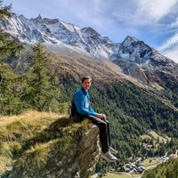
A Landmark-Aware Visual Navigation Dataset
Map representation learned by expert demonstrations has shown promising research value. However, recent advancements in the visual navigation field face challenges due to the lack of human datasets in the real world for efficient supervised representation learning of the environments. We present a Landmark-Aware Visual Navigation (LAVN) dataset to allow for supervised learning of human-centric exploration policies and map building. We collect RGB observation and human point-click pairs as a human annotator explores virtual and real-world environments with the goal of full coverage exploration of the space. The human annotators also provide distinct landmark examples along each trajectory, which we intuit will simplify the task of map or graph building and localization. These human point-clicks serve as direct supervision for waypoint prediction when learning to explore in environments. Our dataset covers a wide spectrum of scenes, including rooms in indoor environments, as well as walkways outdoors. Dataset is available at DOI: 10.5281/zenodo.10608067.
Sparse Semantic Map-Based Monocular Localization in Traffic Scenes Using Learned 2D-3D Point-Line Correspondences
Vision-based localization in a prior map is of crucial importance for autonomous vehicles. Given a query image, the goal is to estimate the camera pose corresponding to the prior map, and the key is the registration problem of camera images within the map. While autonomous vehicles drive on the road under occlusion (e.g., car, bus, truck) and changing environment appearance (e.g., illumination changes, seasonal variation), existing approaches rely heavily on dense point descriptors at the feature level to solve the registration problem, entangling features with appearance and occlusion. As a result, they often fail to estimate the correct poses. To address these issues, we propose a sparse semantic map-based monocular localization method, which solves 2D-3D registration via a well-designed deep neural network. Given a sparse semantic map that consists of simplified elements (e.g., pole lines, traffic sign midpoints) with multiple semantic labels, the camera pose is then estimated by learning the corresponding features between the 2D semantic elements from the image and the 3D elements from the sparse semantic map. The proposed sparse semantic map-based localization approach is robust against occlusion and long-term appearance changes in the environments. Extensive experimental results show that the proposed method outperforms the state-of-the-art approaches.
Producing and Leveraging Online Map Uncertainty in Trajectory Prediction
High-definition (HD) maps have played an integral role in the development of modern autonomous vehicle (AV) stacks, albeit with high associated labeling and maintenance costs. As a result, many recent works have proposed methods for estimating HD maps online from sensor data, enabling AVs to operate outside of previously-mapped regions. However, current online map estimation approaches are developed in isolation of their downstream tasks, complicating their integration in AV stacks. In particular, they do not produce uncertainty or confidence estimates. In this work, we extend multiple state-of-the-art online map estimation methods to additionally estimate uncertainty and show how this enables more tightly integrating online mapping with trajectory forecasting. In doing so, we find that incorporating uncertainty yields up to 50% faster training convergence and up to 15% better prediction performance on the real-world nuScenes driving dataset.
Collecting Larg-Scale Robotic Datasets on a High-Speed Mobile Platform
Mobile robotics datasets are essential for research on robotics, for example for research on Simultaneous Localization and Mapping (SLAM). Therefore the ShanghaiTech Mapping Robot was constructed, that features a multitude high-performance sensors and a 16-node cluster to collect all this data. That robot is based on a Clearpath Husky mobile base with a maximum speed of 1 meter per second. This is fine for indoor datasets, but to collect large-scale outdoor datasets a faster platform is needed. This system paper introduces our high-speed mobile platform for data collection. The mapping robot is secured on the rear-steered flatbed car with maximum field of view. Additionally two encoders collect odometry data from two of the car wheels and an external sensor plate houses a downlooking RGB and event camera. With this setup a dataset of more than 10km in the underground parking garage and the outside of our campus was collected and is published with this paper.
RELEAD: Resilient Localization with Enhanced LiDAR Odometry in Adverse Environments
LiDAR-based localization is valuable for applications like mining surveys and underground facility maintenance. However, existing methods can struggle when dealing with uninformative geometric structures in challenging scenarios. This paper presents RELEAD, a LiDAR-centric solution designed to address scan-matching degradation. Our method enables degeneracy-free point cloud registration by solving constrained ESIKF updates in the front end and incorporates multisensor constraints, even when dealing with outlier measurements, through graph optimization based on Graduated Non-Convexity (GNC). Additionally, we propose a robust Incremental Fixed Lag Smoother (rIFL) for efficient GNC-based optimization. RELEAD has undergone extensive evaluation in degenerate scenarios and has outperformed existing state-of-the-art LiDAR-Inertial odometry and LiDAR-Visual-Inertial odometry methods.
Hybrid Imitative Planning with Geometric and Predictive Costs in Off-road Environments
Geometric methods for solving open-world off-road navigation tasks, by learning occupancy and metric maps, provide good generalization but can be brittle in outdoor environments that violate their assumptions (e.g., tall grass). Learning-based methods can directly learn collision-free behavior from raw observations, but are difficult to integrate with standard geometry-based pipelines. This creates an unfortunate conflict -- either use learning and lose out on well-understood geometric navigational components, or do not use it, in favor of extensively hand-tuned geometry-based cost maps. In this work, we reject this dichotomy by designing the learning and non-learning-based components in a way such that they can be effectively combined in a self-supervised manner. Both components contribute to a planning criterion: the learned component contributes predicted traversability as rewards, while the geometric component contributes obstacle cost information. We instantiate and comparatively evaluate our system in both in-distribution and out-of-distribution environments, showing that this approach inherits complementary gains from the learned and geometric components and significantly outperforms either of them. Videos of our results are hosted at https://sites.google.com/view/hybrid-imitative-planning

Illuminating search spaces by mapping elites
Many fields use search algorithms, which automatically explore a search space to find high-performing solutions: chemists search through the space of molecules to discover new drugs; engineers search for stronger, cheaper, safer designs, scientists search for models that best explain data, etc. The goal of search algorithms has traditionally been to return the single highest-performing solution in a search space. Here we describe a new, fundamentally different type of algorithm that is more useful because it provides a holistic view of how high-performing solutions are distributed throughout a search space. It creates a map of high-performing solutions at each point in a space defined by dimensions of variation that a user gets to choose. This Multi-dimensional Archive of Phenotypic Elites (MAP-Elites) algorithm illuminates search spaces, allowing researchers to understand how interesting attributes of solutions combine to affect performance, either positively or, equally of interest, negatively. For example, a drug company may wish to understand how performance changes as the size of molecules and their cost-to-produce vary. MAP-Elites produces a large diversity of high-performing, yet qualitatively different solutions, which can be more helpful than a single, high-performing solution. Interestingly, because MAP-Elites explores more of the search space, it also tends to find a better overall solution than state-of-the-art search algorithms. We demonstrate the benefits of this new algorithm in three different problem domains ranging from producing modular neural networks to designing simulated and real soft robots. Because MAP- Elites (1) illuminates the relationship between performance and dimensions of interest in solutions, (2) returns a set of high-performing, yet diverse solutions, and (3) improves finding a single, best solution, it will advance science and engineering.
EMMA: End-to-End Multimodal Model for Autonomous Driving
We introduce EMMA, an End-to-end Multimodal Model for Autonomous driving. Built on a multi-modal large language model foundation, EMMA directly maps raw camera sensor data into various driving-specific outputs, including planner trajectories, perception objects, and road graph elements. EMMA maximizes the utility of world knowledge from the pre-trained large language models, by representing all non-sensor inputs (e.g. navigation instructions and ego vehicle status) and outputs (e.g. trajectories and 3D locations) as natural language text. This approach allows EMMA to jointly process various driving tasks in a unified language space, and generate the outputs for each task using task-specific prompts. Empirically, we demonstrate EMMA's effectiveness by achieving state-of-the-art performance in motion planning on nuScenes as well as competitive results on the Waymo Open Motion Dataset (WOMD). EMMA also yields competitive results for camera-primary 3D object detection on the Waymo Open Dataset (WOD). We show that co-training EMMA with planner trajectories, object detection, and road graph tasks yields improvements across all three domains, highlighting EMMA's potential as a generalist model for autonomous driving applications. However, EMMA also exhibits certain limitations: it can process only a small amount of image frames, does not incorporate accurate 3D sensing modalities like LiDAR or radar and is computationally expensive. We hope that our results will inspire further research to mitigate these issues and to further evolve the state of the art in autonomous driving model architectures.
LivePose: Online 3D Reconstruction from Monocular Video with Dynamic Camera Poses
Dense 3D reconstruction from RGB images traditionally assumes static camera pose estimates. This assumption has endured, even as recent works have increasingly focused on real-time methods for mobile devices. However, the assumption of a fixed pose for each image does not hold for online execution: poses from real-time SLAM are dynamic and may be updated following events such as bundle adjustment and loop closure. This has been addressed in the RGB-D setting, by de-integrating past views and re-integrating them with updated poses, but it remains largely untreated in the RGB-only setting. We formalize this problem to define the new task of dense online reconstruction from dynamically-posed images. To support further research, we introduce a dataset called LivePose containing the dynamic poses from a SLAM system running on ScanNet. We select three recent reconstruction systems and apply a framework based on de-integration to adapt each one to the dynamic-pose setting. In addition, we propose a novel, non-linear de-integration module that learns to remove stale scene content. We show that responding to pose updates is critical for high-quality reconstruction, and that our de-integration framework is an effective solution.
Accelerating Online Mapping and Behavior Prediction via Direct BEV Feature Attention
Understanding road geometry is a critical component of the autonomous vehicle (AV) stack. While high-definition (HD) maps can readily provide such information, they suffer from high labeling and maintenance costs. Accordingly, many recent works have proposed methods for estimating HD maps online from sensor data. The vast majority of recent approaches encode multi-camera observations into an intermediate representation, e.g., a bird's eye view (BEV) grid, and produce vector map elements via a decoder. While this architecture is performant, it decimates much of the information encoded in the intermediate representation, preventing downstream tasks (e.g., behavior prediction) from leveraging them. In this work, we propose exposing the rich internal features of online map estimation methods and show how they enable more tightly integrating online mapping with trajectory forecasting. In doing so, we find that directly accessing internal BEV features yields up to 73% faster inference speeds and up to 29% more accurate predictions on the real-world nuScenes dataset.
OCTraN: 3D Occupancy Convolutional Transformer Network in Unstructured Traffic Scenarios
Modern approaches for vision-centric environment perception for autonomous navigation make extensive use of self-supervised monocular depth estimation algorithms that output disparity maps. However, when this disparity map is projected onto 3D space, the errors in disparity are magnified, resulting in a depth estimation error that increases quadratically as the distance from the camera increases. Though Light Detection and Ranging (LiDAR) can solve this issue, it is expensive and not feasible for many applications. To address the challenge of accurate ranging with low-cost sensors, we propose, OCTraN, a transformer architecture that uses iterative-attention to convert 2D image features into 3D occupancy features and makes use of convolution and transpose convolution to efficiently operate on spatial information. We also develop a self-supervised training pipeline to generalize the model to any scene by eliminating the need for LiDAR ground truth by substituting it with pseudo-ground truth labels obtained from boosted monocular depth estimation.
Towards Sensor Data Abstraction of Autonomous Vehicle Perception Systems
Full-stack autonomous driving perception modules usually consist of data-driven models based on multiple sensor modalities. However, these models might be biased to the sensor setup used for data acquisition. This bias can seriously impair the perception models' transferability to new sensor setups, which continuously occur due to the market's competitive nature. We envision sensor data abstraction as an interface between sensor data and machine learning applications for highly automated vehicles (HAD). For this purpose, we review the primary sensor modalities, camera, lidar, and radar, published in autonomous-driving related datasets, examine single sensor abstraction and abstraction of sensor setups, and identify critical paths towards an abstraction of sensor data from multiple perception configurations.

Home Run: Finding Your Way Home by Imagining Trajectories
When studying unconstrained behaviour and allowing mice to leave their cage to navigate a complex labyrinth, the mice exhibit foraging behaviour in the labyrinth searching for rewards, returning to their home cage now and then, e.g. to drink. Surprisingly, when executing such a ``home run'', the mice do not follow the exact reverse path, in fact, the entry path and home path have very little overlap. Recent work proposed a hierarchical active inference model for navigation, where the low level model makes inferences about hidden states and poses that explain sensory inputs, whereas the high level model makes inferences about moving between locations, effectively building a map of the environment. However, using this ``map'' for planning, only allows the agent to find trajectories that it previously explored, far from the observed mice's behaviour. In this paper, we explore ways of incorporating before-unvisited paths in the planning algorithm, by using the low level generative model to imagine potential, yet undiscovered paths. We demonstrate a proof of concept in a grid-world environment, showing how an agent can accurately predict a new, shorter path in the map leading to its starting point, using a generative model learnt from pixel-based observations.

End-to-end Autonomous Driving: Challenges and Frontiers
The autonomous driving community has witnessed a rapid growth in approaches that embrace an end-to-end algorithm framework, utilizing raw sensor input to generate vehicle motion plans, instead of concentrating on individual tasks such as detection and motion prediction. End-to-end systems, in comparison to modular pipelines, benefit from joint feature optimization for perception and planning. This field has flourished due to the availability of large-scale datasets, closed-loop evaluation, and the increasing need for autonomous driving algorithms to perform effectively in challenging scenarios. In this survey, we provide a comprehensive analysis of more than 250 papers, covering the motivation, roadmap, methodology, challenges, and future trends in end-to-end autonomous driving. We delve into several critical challenges, including multi-modality, interpretability, causal confusion, robustness, and world models, amongst others. Additionally, we discuss current advancements in foundation models and visual pre-training, as well as how to incorporate these techniques within the end-to-end driving framework. To facilitate future research, we maintain an active repository that contains up-to-date links to relevant literature and open-source projects at https://github.com/OpenDriveLab/End-to-end-Autonomous-Driving.


Sparse 3D Topological Graphs for Micro-Aerial Vehicle Planning
Micro-Aerial Vehicles (MAVs) have the advantage of moving freely in 3D space. However, creating compact and sparse map representations that can be efficiently used for planning for such robots is still an open problem. In this paper, we take maps built from noisy sensor data and construct a sparse graph containing topological information that can be used for 3D planning. We use a Euclidean Signed Distance Field, extract a 3D Generalized Voronoi Diagram (GVD), and obtain a thin skeleton diagram representing the topological structure of the environment. We then convert this skeleton diagram into a sparse graph, which we show is resistant to noise and changes in resolution. We demonstrate global planning over this graph, and the orders of magnitude speed-up it offers over other common planning methods. We validate our planning algorithm in real maps built onboard an MAV, using RGB-D sensing.
SPINE: Online Semantic Planning for Missions with Incomplete Natural Language Specifications in Unstructured Environments
As robots become increasingly capable, users will want to describe high-level missions and have robots infer the relevant details. because pre-built maps are difficult to obtain in many realistic settings, accomplishing such missions will require the robot to map and plan online. while many semantic planning methods operate online, they are typically designed for well specified missions such as object search or exploration. recently, large language models (LLMs) have demonstrated powerful contextual reasoning abilities over a range of robotic tasks described in natural language. however, existing LLM-enabled planners typically do not consider online planning or complex missions; rather, relevant subtasks and semantics are provided by a pre-built map or a user. we address these limitations via spine, an online planner for missions with incomplete mission specifications provided in natural language. the planner uses an LLM to reason about subtasks implied by the mission specification and then realizes these subtasks in a receding horizon framework. tasks are automatically validated for safety and refined online with new map observations. we evaluate spine in simulation and real-world settings with missions that require multiple steps of semantic reasoning and exploration in cluttered outdoor environments of over 20,000m^2. compared to baselines that use existing LLM-enabled planning approaches, our method is over twice as efficient in terms of time and distance, requires less user interactions, and does not require a full map. Additional resources are provided at: https://zacravichandran.github.io/SPINE.

Vision-Only Robot Navigation in a Neural Radiance World
Neural Radiance Fields (NeRFs) have recently emerged as a powerful paradigm for the representation of natural, complex 3D scenes. NeRFs represent continuous volumetric density and RGB values in a neural network, and generate photo-realistic images from unseen camera viewpoints through ray tracing. We propose an algorithm for navigating a robot through a 3D environment represented as a NeRF using only an on-board RGB camera for localization. We assume the NeRF for the scene has been pre-trained offline, and the robot's objective is to navigate through unoccupied space in the NeRF to reach a goal pose. We introduce a trajectory optimization algorithm that avoids collisions with high-density regions in the NeRF based on a discrete time version of differential flatness that is amenable to constraining the robot's full pose and control inputs. We also introduce an optimization based filtering method to estimate 6DoF pose and velocities for the robot in the NeRF given only an onboard RGB camera. We combine the trajectory planner with the pose filter in an online replanning loop to give a vision-based robot navigation pipeline. We present simulation results with a quadrotor robot navigating through a jungle gym environment, the inside of a church, and Stonehenge using only an RGB camera. We also demonstrate an omnidirectional ground robot navigating through the church, requiring it to reorient to fit through the narrow gap. Videos of this work can be found at https://mikh3x4.github.io/nerf-navigation/ .

Vanishing Point Estimation in Uncalibrated Images with Prior Gravity Direction
We tackle the problem of estimating a Manhattan frame, i.e. three orthogonal vanishing points, and the unknown focal length of the camera, leveraging a prior vertical direction. The direction can come from an Inertial Measurement Unit that is a standard component of recent consumer devices, e.g., smartphones. We provide an exhaustive analysis of minimal line configurations and derive two new 2-line solvers, one of which does not suffer from singularities affecting existing solvers. Additionally, we design a new non-minimal method, running on an arbitrary number of lines, to boost the performance in local optimization. Combining all solvers in a hybrid robust estimator, our method achieves increased accuracy even with a rough prior. Experiments on synthetic and real-world datasets demonstrate the superior accuracy of our method compared to the state of the art, while having comparable runtimes. We further demonstrate the applicability of our solvers for relative rotation estimation. The code is available at https://github.com/cvg/VP-Estimation-with-Prior-Gravity.

PEANUT: Predicting and Navigating to Unseen Targets
Efficient ObjectGoal navigation (ObjectNav) in novel environments requires an understanding of the spatial and semantic regularities in environment layouts. In this work, we present a straightforward method for learning these regularities by predicting the locations of unobserved objects from incomplete semantic maps. Our method differs from previous prediction-based navigation methods, such as frontier potential prediction or egocentric map completion, by directly predicting unseen targets while leveraging the global context from all previously explored areas. Our prediction model is lightweight and can be trained in a supervised manner using a relatively small amount of passively collected data. Once trained, the model can be incorporated into a modular pipeline for ObjectNav without the need for any reinforcement learning. We validate the effectiveness of our method on the HM3D and MP3D ObjectNav datasets. We find that it achieves the state-of-the-art on both datasets, despite not using any additional data for training.
Calibrating Panoramic Depth Estimation for Practical Localization and Mapping
The absolute depth values of surrounding environments provide crucial cues for various assistive technologies, such as localization, navigation, and 3D structure estimation. We propose that accurate depth estimated from panoramic images can serve as a powerful and light-weight input for a wide range of downstream tasks requiring 3D information. While panoramic images can easily capture the surrounding context from commodity devices, the estimated depth shares the limitations of conventional image-based depth estimation; the performance deteriorates under large domain shifts and the absolute values are still ambiguous to infer from 2D observations. By taking advantage of the holistic view, we mitigate such effects in a self-supervised way and fine-tune the network with geometric consistency during the test phase. Specifically, we construct a 3D point cloud from the current depth prediction and project the point cloud at various viewpoints or apply stretches on the current input image to generate synthetic panoramas. Then we minimize the discrepancy of the 3D structure estimated from synthetic images without collecting additional data. We empirically evaluate our method in robot navigation and map-free localization where our method shows large performance enhancements. Our calibration method can therefore widen the applicability under various external conditions, serving as a key component for practical panorama-based machine vision systems.
M3TR: A Generalist Model for Real-World HD Map Completion
Autonomous vehicles rely on HD maps for their operation, but offline HD maps eventually become outdated. For this reason, online HD map construction methods use live sensor data to infer map information instead. Research on real map changes shows that oftentimes entire parts of an HD map remain unchanged and can be used as a prior. We therefore introduce M3TR (Multi-Masking Map Transformer), a generalist approach for HD map completion both with and without offline HD map priors. As a necessary foundation, we address shortcomings in ground truth labels for Argoverse 2 and nuScenes and propose the first comprehensive benchmark for HD map completion. Unlike existing models that specialize in a single kind of map change, which is unrealistic for deployment, our Generalist model handles all kinds of changes, matching the effectiveness of Expert models. With our map masking as augmentation regime, we can even achieve a +1.4 mAP improvement without a prior. Finally, by fully utilizing prior HD map elements and optimizing query designs, M3TR outperforms existing methods by +4.3 mAP while being the first real-world deployable model for offline HD map priors. Code is available at https://github.com/immel-f/m3tr

GLEAM: Learning Generalizable Exploration Policy for Active Mapping in Complex 3D Indoor Scenes
Generalizable active mapping in complex unknown environments remains a critical challenge for mobile robots. Existing methods, constrained by insufficient training data and conservative exploration strategies, exhibit limited generalizability across scenes with diverse layouts and complex connectivity. To enable scalable training and reliable evaluation, we introduce GLEAM-Bench, the first large-scale benchmark designed for generalizable active mapping with 1,152 diverse 3D scenes from synthetic and real-scan datasets. Building upon this foundation, we propose GLEAM, a unified generalizable exploration policy for active mapping. Its superior generalizability comes mainly from our semantic representations, long-term navigable goals, and randomized strategies. It significantly outperforms state-of-the-art methods, achieving 66.50% coverage (+9.49%) with efficient trajectories and improved mapping accuracy on 128 unseen complex scenes. Project page: https://xiao-chen.tech/gleam/.


Select2Plan: Training-Free ICL-Based Planning through VQA and Memory Retrieval
This study explores the potential of off-the-shelf Vision-Language Models (VLMs) for high-level robot planning in the context of autonomous navigation. Indeed, while most of existing learning-based approaches for path planning require extensive task-specific training/fine-tuning, we demonstrate how such training can be avoided for most practical cases. To do this, we introduce Select2Plan (S2P), a novel training-free framework for high-level robot planning which completely eliminates the need for fine-tuning or specialised training. By leveraging structured Visual Question-Answering (VQA) and In-Context Learning (ICL), our approach drastically reduces the need for data collection, requiring a fraction of the task-specific data typically used by trained models, or even relying only on online data. Our method facilitates the effective use of a generally trained VLM in a flexible and cost-efficient way, and does not require additional sensing except for a simple monocular camera. We demonstrate its adaptability across various scene types, context sources, and sensing setups. We evaluate our approach in two distinct scenarios: traditional First-Person View (FPV) and infrastructure-driven Third-Person View (TPV) navigation, demonstrating the flexibility and simplicity of our method. Our technique significantly enhances the navigational capabilities of a baseline VLM of approximately 50% in TPV scenario, and is comparable to trained models in the FPV one, with as few as 20 demonstrations.

MBPTrack: Improving 3D Point Cloud Tracking with Memory Networks and Box Priors
3D single object tracking has been a crucial problem for decades with numerous applications such as autonomous driving. Despite its wide-ranging use, this task remains challenging due to the significant appearance variation caused by occlusion and size differences among tracked targets. To address these issues, we present MBPTrack, which adopts a Memory mechanism to utilize past information and formulates localization in a coarse-to-fine scheme using Box Priors given in the first frame. Specifically, past frames with targetness masks serve as an external memory, and a transformer-based module propagates tracked target cues from the memory to the current frame. To precisely localize objects of all sizes, MBPTrack first predicts the target center via Hough voting. By leveraging box priors given in the first frame, we adaptively sample reference points around the target center that roughly cover the target of different sizes. Then, we obtain dense feature maps by aggregating point features into the reference points, where localization can be performed more effectively. Extensive experiments demonstrate that MBPTrack achieves state-of-the-art performance on KITTI, nuScenes and Waymo Open Dataset, while running at 50 FPS on a single RTX3090 GPU.
NeRF-LOAM: Neural Implicit Representation for Large-Scale Incremental LiDAR Odometry and Mapping
Simultaneously odometry and mapping using LiDAR data is an important task for mobile systems to achieve full autonomy in large-scale environments. However, most existing LiDAR-based methods prioritize tracking quality over reconstruction quality. Although the recently developed neural radiance fields (NeRF) have shown promising advances in implicit reconstruction for indoor environments, the problem of simultaneous odometry and mapping for large-scale scenarios using incremental LiDAR data remains unexplored. To bridge this gap, in this paper, we propose a novel NeRF-based LiDAR odometry and mapping approach, NeRF-LOAM, consisting of three modules neural odometry, neural mapping, and mesh reconstruction. All these modules utilize our proposed neural signed distance function, which separates LiDAR points into ground and non-ground points to reduce Z-axis drift, optimizes odometry and voxel embeddings concurrently, and in the end generates dense smooth mesh maps of the environment. Moreover, this joint optimization allows our NeRF-LOAM to be pre-trained free and exhibit strong generalization abilities when applied to different environments. Extensive evaluations on three publicly available datasets demonstrate that our approach achieves state-of-the-art odometry and mapping performance, as well as a strong generalization in large-scale environments utilizing LiDAR data. Furthermore, we perform multiple ablation studies to validate the effectiveness of our network design. The implementation of our approach will be made available at https://github.com/JunyuanDeng/NeRF-LOAM.
Deep Network Uncertainty Maps for Indoor Navigation
Most mobile robots for indoor use rely on 2D laser scanners for localization, mapping and navigation. These sensors, however, cannot detect transparent surfaces or measure the full occupancy of complex objects such as tables. Deep Neural Networks have recently been proposed to overcome this limitation by learning to estimate object occupancy. These estimates are nevertheless subject to uncertainty, making the evaluation of their confidence an important issue for these measures to be useful for autonomous navigation and mapping. In this work we approach the problem from two sides. First we discuss uncertainty estimation in deep models, proposing a solution based on a fully convolutional neural network. The proposed architecture is not restricted by the assumption that the uncertainty follows a Gaussian model, as in the case of many popular solutions for deep model uncertainty estimation, such as Monte-Carlo Dropout. We present results showing that uncertainty over obstacle distances is actually better modeled with a Laplace distribution. Then, we propose a novel approach to build maps based on Deep Neural Network uncertainty models. In particular, we present an algorithm to build a map that includes information over obstacle distance estimates while taking into account the level of uncertainty in each estimate. We show how the constructed map can be used to increase global navigation safety by planning trajectories which avoid areas of high uncertainty, enabling higher autonomy for mobile robots in indoor settings.
Object Goal Navigation with Recursive Implicit Maps
Object goal navigation aims to navigate an agent to locations of a given object category in unseen environments. Classical methods explicitly build maps of environments and require extensive engineering while lacking semantic information for object-oriented exploration. On the other hand, end-to-end learning methods alleviate manual map design and predict actions using implicit representations. Such methods, however, lack an explicit notion of geometry and may have limited ability to encode navigation history. In this work, we propose an implicit spatial map for object goal navigation. Our implicit map is recursively updated with new observations at each step using a transformer. To encourage spatial reasoning, we introduce auxiliary tasks and train our model to reconstruct explicit maps as well as to predict visual features, semantic labels and actions. Our method significantly outperforms the state of the art on the challenging MP3D dataset and generalizes well to the HM3D dataset. We successfully deploy our model on a real robot and achieve encouraging object goal navigation results in real scenes using only a few real-world demonstrations. Code, trained models and videos are available at https://www.di.ens.fr/willow/research/onav_rim/.
End-to-End Learned Event- and Image-based Visual Odometry
Visual Odometry (VO) is crucial for autonomous robotic navigation, especially in GPS-denied environments like planetary terrains. While standard RGB cameras struggle in low-light or high-speed motion, event-based cameras offer high dynamic range and low latency. However, seamlessly integrating asynchronous event data with synchronous frames remains challenging. We introduce RAMP-VO, the first end-to-end learned event- and image-based VO system. It leverages novel Recurrent, Asynchronous, and Massively Parallel (RAMP) encoders that are 8x faster and 20% more accurate than existing asynchronous encoders. RAMP-VO further employs a novel pose forecasting technique to predict future poses for initialization. Despite being trained only in simulation, RAMP-VO outperforms image- and event-based methods by 52% and 20%, respectively, on traditional, real-world benchmarks as well as newly introduced Apollo and Malapert landing sequences, paving the way for robust and asynchronous VO in space.
GridRoute: A Benchmark for LLM-Based Route Planning with Cardinal Movement in Grid Environments
Recent advancements in Large Language Models (LLMs) have demonstrated their potential in planning and reasoning tasks, offering a flexible alternative to classical pathfinding algorithms. However, most existing studies focus on LLMs' independent reasoning capabilities and overlook the potential synergy between LLMs and traditional algorithms. To fill this gap, we propose a comprehensive evaluation benchmark GridRoute to assess how LLMs can take advantage of traditional algorithms. We also propose a novel hybrid prompting technique called Algorithm of Thought (AoT), which introduces traditional algorithms' guidance into prompting. Our benchmark evaluates six LLMs ranging from 7B to 72B parameters across various map sizes, assessing their performance in correctness, optimality, and efficiency in grid environments with varying sizes. Our results show that AoT significantly boosts performance across all model sizes, particularly in larger or more complex environments, suggesting a promising approach to addressing path planning challenges. Our code is open-sourced at https://github.com/LinChance/GridRoute.

Game4Loc: A UAV Geo-Localization Benchmark from Game Data
The vision-based geo-localization technology for UAV, serving as a secondary source of GPS information in addition to the global navigation satellite systems (GNSS), can still operate independently in the GPS-denied environment. Recent deep learning based methods attribute this as the task of image matching and retrieval. By retrieving drone-view images in geo-tagged satellite image database, approximate localization information can be obtained. However, due to high costs and privacy concerns, it is usually difficult to obtain large quantities of drone-view images from a continuous area. Existing drone-view datasets are mostly composed of small-scale aerial photography with a strong assumption that there exists a perfect one-to-one aligned reference image for any query, leaving a significant gap from the practical localization scenario. In this work, we construct a large-range contiguous area UAV geo-localization dataset named GTA-UAV, featuring multiple flight altitudes, attitudes, scenes, and targets using modern computer games. Based on this dataset, we introduce a more practical UAV geo-localization task including partial matches of cross-view paired data, and expand the image-level retrieval to the actual localization in terms of distance (meters). For the construction of drone-view and satellite-view pairs, we adopt a weight-based contrastive learning approach, which allows for effective learning while avoiding additional post-processing matching steps. Experiments demonstrate the effectiveness of our data and training method for UAV geo-localization, as well as the generalization capabilities to real-world scenarios.


cuVSLAM: CUDA accelerated visual odometry and mapping
Accurate and robust pose estimation is a key requirement for any autonomous robot. We present cuVSLAM, a state-of-the-art solution for visual simultaneous localization and mapping, which can operate with a variety of visual-inertial sensor suites, including multiple RGB and depth cameras, and inertial measurement units. cuVSLAM supports operation with as few as one RGB camera to as many as 32 cameras, in arbitrary geometric configurations, thus supporting a wide range of robotic setups. cuVSLAM is specifically optimized using CUDA to deploy in real-time applications with minimal computational overhead on edge-computing devices such as the NVIDIA Jetson. We present the design and implementation of cuVSLAM, example use cases, and empirical results on several state-of-the-art benchmarks demonstrating the best-in-class performance of cuVSLAM.
LM-Nav: Robotic Navigation with Large Pre-Trained Models of Language, Vision, and Action
Goal-conditioned policies for robotic navigation can be trained on large, unannotated datasets, providing for good generalization to real-world settings. However, particularly in vision-based settings where specifying goals requires an image, this makes for an unnatural interface. Language provides a more convenient modality for communication with robots, but contemporary methods typically require expensive supervision, in the form of trajectories annotated with language descriptions. We present a system, LM-Nav, for robotic navigation that enjoys the benefits of training on unannotated large datasets of trajectories, while still providing a high-level interface to the user. Instead of utilizing a labeled instruction following dataset, we show that such a system can be constructed entirely out of pre-trained models for navigation (ViNG), image-language association (CLIP), and language modeling (GPT-3), without requiring any fine-tuning or language-annotated robot data. We instantiate LM-Nav on a real-world mobile robot and demonstrate long-horizon navigation through complex, outdoor environments from natural language instructions. For videos of our experiments, code release, and an interactive Colab notebook that runs in your browser, please check out our project page https://sites.google.com/view/lmnav
RELAX: Reinforcement Learning Enabled 2D-LiDAR Autonomous System for Parsimonious UAVs
Unmanned Aerial Vehicles (UAVs) have become increasingly prominence in recent years, finding applications in surveillance, package delivery, among many others. Despite considerable efforts in developing algorithms that enable UAVs to navigate through complex unknown environments autonomously, they often require expensive hardware and sensors, such as RGB-D cameras and 3D-LiDAR, leading to a persistent trade-off between performance and cost. To this end, we propose RELAX, a novel end-to-end autonomous framework that is exceptionally cost-efficient, requiring only a single 2D-LiDAR to enable UAVs operating in unknown environments. Specifically, RELAX comprises three components: a pre-processing map constructor; an offline mission planner; and a reinforcement learning (RL)-based online re-planner. Experiments demonstrate that RELAX offers more robust dynamic navigation compared to existing algorithms, while only costing a fraction of the others. The code will be made public upon acceptance.

EndoGSLAM: Real-Time Dense Reconstruction and Tracking in Endoscopic Surgeries using Gaussian Splatting
Precise camera tracking, high-fidelity 3D tissue reconstruction, and real-time online visualization are critical for intrabody medical imaging devices such as endoscopes and capsule robots. However, existing SLAM (Simultaneous Localization and Mapping) methods often struggle to achieve both complete high-quality surgical field reconstruction and efficient computation, restricting their intraoperative applications among endoscopic surgeries. In this paper, we introduce EndoGSLAM, an efficient SLAM approach for endoscopic surgeries, which integrates streamlined Gaussian representation and differentiable rasterization to facilitate over 100 fps rendering speed during online camera tracking and tissue reconstructing. Extensive experiments show that EndoGSLAM achieves a better trade-off between intraoperative availability and reconstruction quality than traditional or neural SLAM approaches, showing tremendous potential for endoscopic surgeries. The project page is at https://EndoGSLAM.loping151.com